Warning
This trail has only been partially surveyed at this time. Length and other trail data may be incorrect or missing. Please consult other resources before planning any trips based on this page.
Cottonwood Trail #233
Important Note
This trail should not be confused with the Cottonwood Fire Canyon Trail or Cottonwood – John Long Trail.
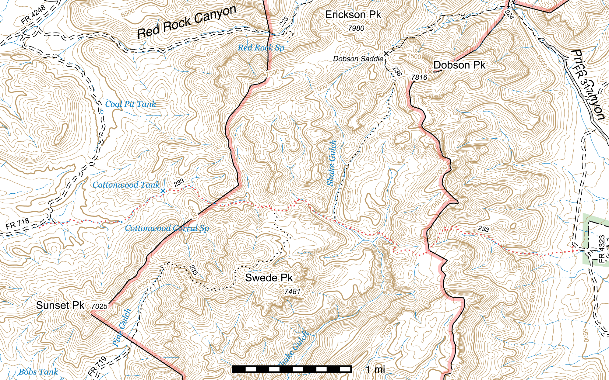
Most maps do not show this trail in its correct position. The segment east of Shake Gulch is in particular highly inaccurate on almost every map—its actual position is half a mile to a mile south of where it is drawn on USGS/USFS maps. Refer to the map at the bottom of this page for an accurate position.
Length: ~6.30 mi
Difficulty: difficult
Condition: terrible
Elevation range: 5565 ft – 6820 ft
Access
The Cottonwood Trail is accessible from three or more locations, not all of which have been surveyed at this time.
The western terminus is located at the junction of the Cottonwood Canyon Road (FR 718) and the Coal Pit Tank Road (FR 4248). (31.73303, -109.33141) Both of these roads are very rough and rocky, and high clearance 4WD vehicles are a must. From Tex Canyon Road (FR 41), 1.5 miles southeast of the Rucker Canyon Road (FR 74E) junction, turn east onto FR 718 at the sign for Cottonwood Canyon. (31.74530, -109.35189) Follow this 1.79 miles to the trailhead. There are several parking opportunities early on, and it is highly recommended to park and walk if you are concerned about being able to drive on the road. From the FR 718 and FR 4248 junction, which is marked with road and trail signs, the trail travels atop an old roadbed for the first 1000 feet. The primary trail sign is at the beginning of the singletrack trail. (31.73345, -109.32851)
The Pine Gulch Trail's northern terminus is located midway along the Cottonwood Trail, atop a ridge. This junction is marked by several old but fallen and unreadable signs, as well as several large rock cairns. (31.73534, -109.29697)
The trail crosses Shake Gulch, which is allegedly the southern terminus of a virtually nonexistent segment of the Price Shake Trail. This junction is unsigned. (31.73383, -109.28833)
The eastern terminus is located near a bend in an unnamed and unnumbered old, undrivable, abandoned road connecting to the Price Canyon Road (FR 317). From Highway 80, take the Price Canyon Road 5.6 miles to the Forest boundary, then continue 1.3 miles to a fork in the road. Following the signs for Price Canyon, turn left. Several hundred feet beyond, take the right fork. Continue another 3.3 miles until you come to an old road on the left, blocked off by large boulders. There is parking for at least one vehicle on the right side of the road. (31.74733, -109.25054) On foot, follow the old road for 1.3 miles as it heads southwest across Price Creek and then curves south. Near the end, the road (heavily flood damaged here) turns abruptly to the southeast and heads to a gate at a private land inholding boundary. Before you reach the gate, head south towards a barbed wire pasture fence. You should be able to pick up the trail in the grass before you reach the fence. If not, head west along the fence and you will eventually see it. The trailhead along the road is unsigned, but the trail can still be faintly seen there. (31.72968, -109.25279)
Trail Description
Cottonwood Canyon Road to Pine Gulch Trail
- 2.56 mi
- 960 ft ↑ 20 ft ↓
- 7% slope
From the signed junction of Cottonwood Canyon Road (FR 718) and Coal Pit Tank Road (FR 4248) (31.73303, -109.33141), the Cottonwood Trail heads southeast atop an old roadbed. The trailhead is signed here, but not by name. After about 100 feet, the trail crosses Cottonwood Creek and shortly after swings northeast to parallel the creek. After just over a tenth of a mile, it drops into the creekbed and disappears. Follow the canyon bottom upstream for about 250 feet and you will be at the beginning of the single track trail, (32.05210, -109.30962) which climbs away from the creek to the east and is marked by a relatively new trailhead sign identifying the trail by name. At this same location, a faint hint of a path can be seen climbing out of the creek on the northwest side. This can be followed roughly 200 feet in that direction to a dirt tank with several cottonwood trees growing around it. (31.73386, -109.32906)
From the trail sign, the Cottonwood Trail heads roughly east, on the south side of the creek. After 200 feet, a bedrock cascade can be seen where a small side drainage crosses from the south. (31.73357, -109.32795) Another nearly 0.1 mile beyond, the trail having curved towards the northeast, it crosses to the creek's north side (31.73392, -109.32655) and turns to parallel it as it swings east. The trail is only slightly higher than the creek here in places, but remarkably visible and easy to follow. The ruins of a small rock-walled structure (31.73393, -109.32436) lie just north of the trail 750 feet after the previous crossing and 150 feet before the next.
After 0.16 mile on the south side of the creek again, the trail exits the relatively intact tree cover that has been prevalent until now and, just as it drops down into the creekbed and disappears, enters a very large stretch of heavy burn from the 2011 Horseshoe 2 fire. (31.73381, -109.32142) There is little trace of the trail for the following 350 feet and you'll need to stick to the bottom of the canyon. It then climbs a short distance above the creekbed on the south side (31.73364, -109.32034) but only for 330 feet, which you can either follow or stick to the creek.
The next creek crossing (31.73376, -109.31932) is about 90 feet northwest of Cottonwood Corral Spring, which lies directly in the bottom of the canyon and has been heavily damaged by flooding. (31.73365, -109.31905) The concrete trough has been filled with with rocks and gravel and the pipe that once fed it is broken. You can sometimes find puddles of water a short distance up-creek from it, but they may not be good for drinking due to the presence of cattle in the area.
Back at the crossing, the trail continues east, climbing up onto the bank north of the creek. The burnt ruins of Cottonwood Corral begin 200 feet east-northeast of the crossing (31.73386, -109.31870) and the trail passes directly through it for about 100 feet. The next crossing, almost 500 feet northeast, occurs at the midpoint of an S-curve made by the creek, (31.73495, -109.31747) and here the condition drops significantly again. Follow the creek for 0.12 mile until just before you reach the northeastern edge of this patch of fire damage, at which point you should be able to pick up the trail climbing up the southeastern side of the canyon (31.73602, -109.31621) to bypass a waterfall 250 feet later. (31.73638, -109.31558)
For 630 feet, the trail stays in or close to the canyon bottom, always on the southeastern side. The creek then briefly swings southeast and the trail disappears in a massive field of rock debris from flooding. (31.73741, -109.31411) Keep going up-canyon to the southeast for 150 feet until you reach a large fork in the canyon. (31.73727, -109.31366) Take the left (northern) fork and after about another 150 feet the trail will appear once more, on the eastern side of the canyon. (31.73735, -109.31324)
After alternating at least once from one side of the creek to the other over the next 0.29 mile, the trail once again abruptly disappears into the creek (31.73885, -109.30918) 175 feet northwest of a large concrete dam. 50 feet before reaching the base of the dam, the trail climbs up the west bank with a single switchback to bypass it. (31.73865, -109.30888) The dam is completely silted in to the top, and after dropping back to its upper level, the trail disappears into the creek bottom for the following nearly half a mile, re-entering an area of heavy burn near the dam which remains for the rest of the segment and beyond.
Just before reaching a fork where Cottonwood Creek swings north and a smaller side drainage flows in from the southeast, the trail suddenly appears again—marked by cairns—and climbs up the south bank of Cottonwood Creek. (31.73647, -109.30229) After a few hundred feet paralleling the creek while climbing, the trail swings east-southeast away from it, crosses the side drainage 150 feet later (31.73642, -109.30084) and begins its steeper ascent towards the ridge.
After 400 feet, the first switchback occurs, a smaller one to get things started, (31.73610, -109.29967) followed by about five more over the next almost quarter mile. At the final switchback, (31.73559, -109.29784) the trail heads almost due east for 200 feet to the top of the ridge before swinging southeast just as it crests the top to meet the northern terminus of the Pine Gulch Trail 100 feet later. (31.73534, -109.29697) There are large rock cairns here to mark the junction as well as the unreadable ruins of a Forest Service sign. The Pine Gulch Trail heads almost due south from this point, but is very faint and hard to see for its 0.66 mile northernmost stretch.
Pine Gulch Trail to Shake Gulch
- 0.79 mi
- 480 ft ↓
- 11.5% slope
The Cottonwood Trail heads east through chaparral for 200 feet before contouring with the terrain over the next 700 feet to the edge of a canyon. Several cairns mark the route along here where it is less obvious. Dropping to the canyon bottom requires five switchbacks and nearly two tenths of a mile of trail, during which you will pass below a sheer rock cliff to the west. The point where the trail meets the creekbed is marked with a large cairn. (31.73703, -109.29370)
The trail then follows the canyon downstream to the southwest. Occasional segments of definitive trail can be found on the right bank of the canyon bottom in places, but they are badly overgrown. The gravely creekbed is easier to follow at present. The overgrown trail drops back to the creekbed once the canyon meets Shake Gulch at the no-longer-actually-existing Price Shake Trail Junction. (31.73383, -109.28833)
That trail, according to some maps1 2, heads up Shake Gulch to the north and climbs to Dobson Saddle, where it drops down to a junction with the Price Canyon Trail, but the Shake Gulch half of the trail has been almost entirely lost, with only very occasional pieces visible—mostly on the final climb to the saddle. It is possible to bushwhack up Shake Gulch with a good map or GPS, but fire and flooding damage have made it a rough, slow journey.
Shake Gulch to Side Canyon
- 0.51 mi
- 80 ft ↑ 115 ft ↓
- 1.3% slope
The original trail route has not yet been definitively found in this segment. For the time being, follow Shake Gulch southeast for approximately 0.38 mile. You will pass a side canyon—Gila Monster Canyon—on your right, coming in to Shake Gulch from the southwest. (31.73108, -109.28410) Continue another 100 yards to a second side canyon, this one on the left and coming in from the north-northeast. (31.73074, -109.28313) Follow this for 0.13 mile, taking the left fork if you notice a smaller canyon coming in from the right. Towards the end, just beyond the smaller canyon, you will pass a sheer rock cliff on your right. Continue to the end of this, then head east up the slope to a flat area above the rock cliffs. (31.73200, -109.28168) The Cottonwood Trail isn't immediately clear here, but it heads east from a spot just north of the cliffs.
Side Canyon to Ridgetop
- 0.73 mi
- 460 ft ↑ 20 ft ↓
- 11.4% slope
Curving southeast, with a possible switchback as it climbs gradually, the trail exits the area of the cliffs and becomes more visible (though still overgrown), climbing somewhat more aggressively. After approximately 300 feet heading southeast, the trail switches back to the north (31.73137, -109.28100), then again to the southeast after 40 feet. Two more pairs of switchbacks occur over the next 0.13 mile, each with a longer stretch between heading southeast.
After the fourth, the trail continues southeast for 200 feet before contouring to the southwest across the drainage it's traveling up. 220 feet after the turn, another pair of switchbacks, (31.72994, -109.27976) then it's 160 feet southeast to the top of a ridge (31.72957, -109.28017), whereupon the trail proceeds to turn southeast again and ascend along a fairly visible route, curving northeast in places as it follows it up. This ridge burned hot in places, and the trail can get somewhat faint in places, but it's generally easy to follow through here.
In 0.17 mile you will pass an interesting rock outcrop with some spires on the southwest side of the trail, (31.72951, -109.27752) and 290 feet after the ascends a short, steep section and comes to a rock that makes a good viewpoint of Shake Gulch, Swede Peak, and the surrounding region. (31.72899, -109.27692) Here, too, the trail bends east before arcing its way northeast over the next approximately 0.1 mile, then bending sharply southeast (31.72934, -109.27543) and descending slightly over the next 100 feet through a wooded area with living trees to a metal signpost and an old Forest Service trail sign on the ground that once pointed the direction to Shake Gulch. (31.72920, -109.27515)
Ridgetop to Eastern Terminus
- ~1.71 mi
- 1230 ft ↓
- 13.6% slope
This segment has not been completed at this time.
Map
Footnotes
- http://www.fs.usda.gov/Internet/FSE_MEDIA/fsbdev3_003339.jpg
- USFS Swede Peak Quadrangle Topographic Map
Last updated July 14, 2025.