Warning
This trail has only been partially surveyed at this time. Length and other trail data may be incorrect or missing. Please consult other resources before planning any trips based on this page.
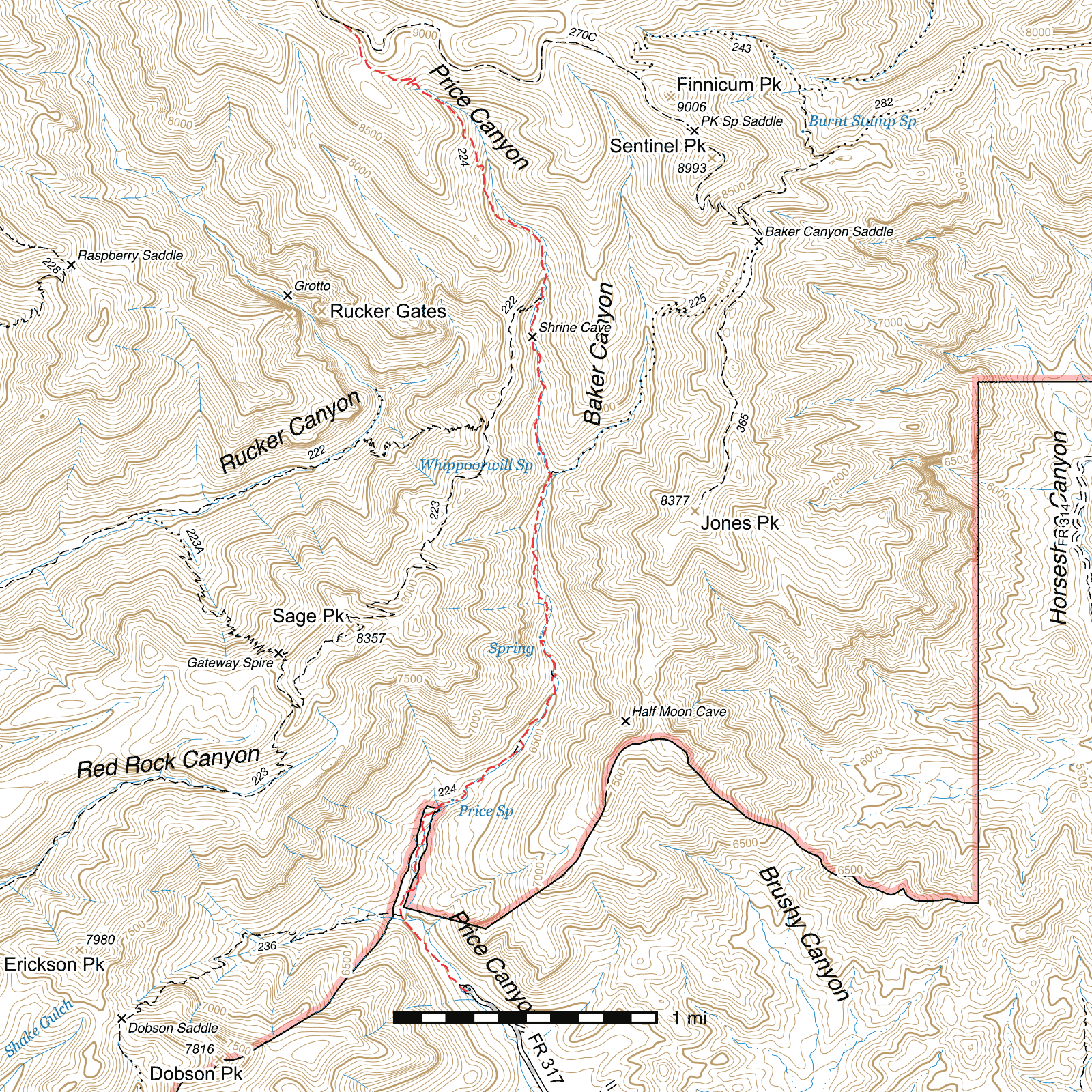
Price Canyon Trail #224
Current Conditions
As of May 2025, this trail has been cleared by the Chiricahua Wilderness Volunteer Trail Crew and a Sierra Club Service Trip approximately as far in as the Baker Canyon Trail junction.
As of February 2026, the trail is brushed as far as the Rucker Canyon Trail junction though logs remain across the trail between the Baker Canyon Trail and Rucker Canyon Trail junctions.
Recent scouting has revealed a moderate condition trail past the Rucker Canyon Trail junction with decent though occasionally faint/disappearing tread in places, light vegetation overgrowth and scattered logs down.
Length: ~5.49 mi
Difficulty: moderate
Condition: moderate
Elevation range: 5840 ft – 9025 ft
Access
The Price Canyon Trail is accessible from four locations.
The lower-elevation southern terminus is at the turnaround loop at the end of Price Canyon Road (FR 317). From Highway 80, turn northwest onto Price Canyon Road 5.7 miles south of the town of Apache. Follow it for 5.6 miles, until you reach the National Forest boundary and the road becomes FR 317. Continue another 1.25 miles before reaching a fork. FR 317 takes the left fork, while a private road to Price Canyon Ranch is along the right fork. There is a sign at this point which clearly indicates which fork to take. A second fork lies 100 feet beyond the left fork and you should take the right fork this time (the left is FR 4323). There is no sign here. After another 1.67 miles, a third fork, this time with Brushy Canyon Road (FR 4322)—take the left-hand road for another half mile to the fourth and final fork in the road, of which you must take the right fork. It's another 2.17 miles from here to the turnaround loop at the end of the road, with a large water tank in the center of the loop. The trailhead lies on the southwest side of the loop and is marked by a trail sign. (31.75974, -109.25862)
The Price Shake Trail heads west up Bull Canyon to Dobson Saddle from a point nearly half a mile above the trailhead. (31.76464, -109.26287) This guide has only surveyed this trail as a dead-end route so far, but old maps, as well as the trail's name, suggest that it continues beyond the saddle into Shake Gulch and connects with the Cottonwood Trail. This junction is marked by a sign.
The Baker Canyon Trail drops down from Sentinel Peak and connects in 2.45 miles up-trail from the previous junction. (31.79324, -109.25318) This junction is marked by a sign, but the trail is faint as it leaves the junction.
The eastern terminus of the Rucker Canyon Trail occurs 0.86 mile above the previous junction, where it drops down to meet the Price Canyon Trail from atop the ridge to the west. (31.80457, -109.25384) This junction is unsigned and overgrown—the signs having burned—and the Rucker Canyon Trail here is covered with downed trees.
The higher-elevation northern terminus is along the southeastern leg of the Crest Trail, 1.31 miles southeast of the Snowshed Trail junction and 1.59 miles northwest of the South Fork Trail junction. (31.82237, -109.26655)
Trail Description
Trailhead to Price Shake Trail
- 0.44 mi
- 150 ft ↑ 5 ft ↓
- 6.2% slope
Heading northwest out of the turnaround loop, you will cross the creek almost immediately and remain on its left bank for the rest of this segment. This trail is frequented by horses and there may be places at the start where several different routes all appear viable.
Price Canyon did burn in the 2011 Horseshoe 2 fire but it was for the most part a light burn, clearing out the underbrush with the vast majority of the canopy remaining intact. You may notice a black pipe running along the right side of the trail in places, sometimes with other, fire-melted pieces nearby. This connects the water tank at the trailhead to Price Spring.
120 feet before the end of this segment, you will cross a (usually dry) side drainage and climb up its other bank to reach the Price Shake Trail junction, located beside a large boulder and marked by signs. (31.76464, -109.26287) This trail heads off to the west up Bull Canyon before climbing to Dobson Saddle between that canyon and Shake Gulch. Dobson Peak and Erickson Peak are both accessible (mostly off-trail) from the saddle.
Price Shake Trail to Price Spring
- 0.63 mi
- 220 ft ↑ 5 ft ↓
- 6.5% slope
A tenth of a mile after leaving the junction, the trail swings to the right and you will cross the creek for the first time shortly after before turning left again to continue paralleling it. Note that some crossings may have changed from how they are described here during recent maintenance post-flooding. At least one additional crossing occurs in this segment, and you will end up back on the left bank before approaching the spring. After a third of a mile, the trail begins to climb up off the canyon floor as it swings to the right and goes around a bend. The creek below has stretches of visible bedrock with occasional pools through this area. The next approximately tenth of a mile to the spring remains like this. 350 feet before the spring, a very visible side drainage off Sage Peak crosses the trail.
The spring itself is on the left side of the trail (31.77206, -109.25942) and usually has little more than a slight seep or some drips, which soak into the trail itself and create a mud patch. There are actually a number of different seeps here, all in the immediate area, and they can at times combine to output enough water to fill the pools downstream.
Price Spring to Baker Canyon Trail
- 1.8 mi
- 830 ft ↑ 25 ft ↓
- 8.5% slope
This segment of the Price Canyon Trail stays largely along the creek, crossing it multiple times along its length. Flooding has obscured portions of the trail, though cairns make the general route easy enough to follow in most places. Several switchbacks occur with the trail changing elevation for a short while, and these can be easy to miss when they occur at creek crossings. One, located 0.8 miles beyond Price Spring, (31.78017, -109.25304) has had downed trees and debris in the area, potentially obscuring the correct crossing point.
The trail also becomes somewhat obscured approximately 100 feet before the Baker Canyon Trail junction. (31.79293, -109.25329) At a creek crossing, you will need to head roughly northeast before swinging back to the north and entering the small clearing where the junction occurs. Once at the junction it is easy to find your away again, as all signs are in place and readable. The Baker Canyon Trail departs to the northeast, but is very faint at this point and can be hard to follow. If you lose track of it, head for the creek bottom coming out of that canyon a short distance beyond. Even if you aren't planning on hiking this trail, a short side trip to visit the narrows may be of interest—this lies a few hundred feet roughly northeast of the junction and is a relatively short stretch of canyon where the rock cliffs narrow to approximately 20 feet wide.
Baker Canyon Trail to Rucker Trail
- 0.86 mi
- 420 ft ↑ 10 ft ↓
- 9% slope
The terrain remaining much the same, this segment has in the past been in somewhat better condition than the previous, with the trail generally quite easy to find and follow. Two thirds of a mile above the previous junction, you will come to a large rock cliff on the left side of the trail, with a cave extending into it for approximately 10 – 15 feet. (31.80212, -109.25433) A shrine to the Virgin of Guadalupe has been erected in this cave by undocumented immigrants who travel this route and a large amount of trash is frequently found around the immediate area.
It's not quite two tenths of a mile beyond to the upper terminus of the Rucker Canyon Trail, which drops down on the left-hand side from the ridge separating Price and Rucker Canyons. (31.80457, -109.25384) This signs that formerly marked this junction have burned and only old pink flagging tape indicated the correct location in the past, though it has likely worn off by now. The stretch of the Rucker Canyon Trail that leads away from here has not been maintained since before the 2011 Horseshoe II fire and there are downed logs and overgrowth obscuring it.
Rucker Trail to Crest Trail
- 1.76 mi
- 1655 ft ↑ 65 ft ↓
- 17.1% slope
This segment contains information submitted by a reader and has not been fully scouted by this guide at this time, so information remains minimal.
Beyond the Rucker Canyon Trail junction, the trail climbs out of the canyon and greatly improves in condition with scattered logs and light vegetation overgrowth.
After approximately 1.3 miles, the tread begins to fade (31.81860, -109.26215) as it enters grassy meadows, though a route has been flagged to the saddle above as of the time of this writing. Once reaching the saddle (31.81950, -109.26489), the tread resumes and can be followed all the way to the Crest Trail.
Map
Last updated February 3, 2026.