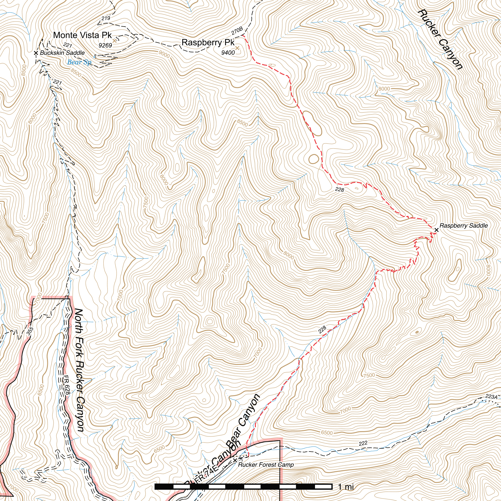
Raspberry Ridge Trail #228
Current Conditions
The lower 2 miles of this trail were restored by Wild Arizona's Youth Conservation Corps crew in summer of 2023, however extensive damage remains above the point where work stopped. There are massive landslides, debris flows, and huge amounts of deadfall. If you plan to continue up this trail from there, good luck.
Length: 4.44 mi
Difficulty: difficult
Condition: terrible
Elevation range: 6195 ft – 9250 ft
Access
The Raspberry Ridge Trail can be accessed from two locations.
The lower elevation southern terminus can be accessed from the former Rucker Forest Camp campground at the end of Rucker Canyon Road, via a short stretch of the Rucker Canyon Trail, which takes off from a small parking area on the north side of the road just before the old campground. You will pass alongside the abandoned campground, continue through a pedestrian gate, and the signed junction with the Raspberry Ridge Trail is just beyond on the left. (31.78501, -109.30234)
The higher elevation northern terminus is a short distance north-northeast of Raspberry Peak, along the Crest Trail between Paint Rock and its western terminus below Monte Vista Peak. This junction was signed but the sign may be damaged or missing. (31.82551, -109.30293)
Trail Description
From a signed junction along the Rucker Canyon Trail, the Raspberry Ridge Trail heads north into Bear Canyon. The trail is initially fairly visible, likely due to its close proximity to Rucker Forest Camp, but as it penetrates deeper into the canyon and parallels the creek (usually dry), it becomes much more faint. You should be able to generally follow it, but there may be points where it disappears for a while. Watch for rock cairns at creek crossings to guide your way, but if you do ever lose the trail, just keep heading up the creek until you pick it up again. Bear Canyon, and the trail, angle gradually to the northeast, and after 1.55 miles of sticking alongside the creek, the trail swings sharply to the right and begins to climb a side drainage. The first switchback occurs 400 feet later and the next 0.8 miles of steep ascent to Raspberry Saddle contains about 30 more. If you're lucky enough to visit during wildflower season, you may have a beautiful sight on the cliffs opposite you to the southwest as you stop frequently to catch your breath.
While the trail briefly levels out at Raspberry Saddle, it begins climbing almost immediately again, this time without the aid of switchbacks. Heading northwest along Raspberry Ridge through rough, rocky terrain, you'll be able to enjoy spectacular views of upper Rucker Canyon deep below as it cuts deep into the range, all the way to the base of Chiricahua Peak. A little over half a mile beyond Raspberry Saddle you'll come to the first of two final switchbacks, the second only 200 feet later, and the stretch between the two so steep you may wonder why more switchbacks weren't utilized. After the final switchback, the trail levels out significantly and skirts around the north edge of a ridge, making a wide bend to the left and then to the right. This area was heavily burned but can be a giant expanse of yellow wildflowers if visited at the right time after the monsoon season. Four tenths of a mile beyond the last switchback, the trail can disappear somewhat under overgrown wildflowers. Head north-northwest along Raspberry Ridge if it disappears and you should pick it up again eventually.
In another half a mile its position becomes better defined again and it spends the final half a mile along the eastern slope of a ridge, staying east of Raspberry Peak, before connecting to the Crest Trail. Monte Vista Peak lies to the left and Chiricahua Peak to the right.
Map
Last updated July 14, 2025.