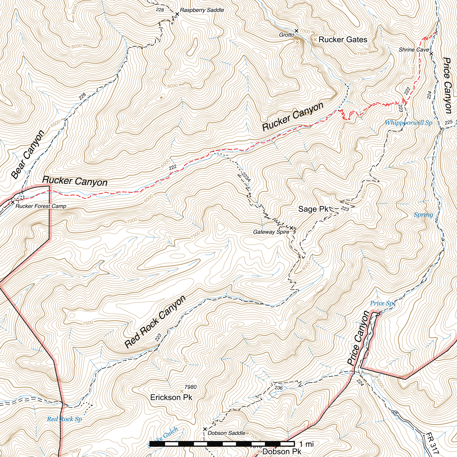
Rucker Canyon Trail #222
Current Conditions
As of November 2025, considerable work has been done on this trail and it is in quite good condition from the trailhead to its junction with the Red Rock Canyon Trail at the top of the switchbacks. In September 2025, Wild Arizona's Wild Stew Field Crew repaired several sections and built a significant reroute around the worst flood damaged portion of the trail, and in October 2025 the Chiricahua Wilderness Volunteer Trail Crew cut over 60 trees off the trail.
As of February 2026, the section between the junction of the Red Rock Canyon Trail and Price Canyon Trail has been brushed and logged out and is significantly improved, making the trail in good condition along its entire length.
Length: 4.66 mi
Difficulty: moderate
Condition: good
Elevation range: 6150 ft – 7620 ft
Access
The Rucker Canyon Trail is accessible from four major locations.
The western terminus is located less than a tenth of a mile before the former site of the Rucker Forest Camp campground at the end of Rucker Canyon Road (FR 74E). A very small parking area can be seen on the left side of the road, with trailhead signs present here. (31.78389, -109.30462) You can walk the trail out of this parking area or walk the closed road through the former campground and pick up the trail at the end.
The southern terminus of the Raspberry Ridge Trail is located along this trail 0.17 miles beyond the trailhead, that trail coming in from the north just beyond a pedestrian gate on the Rucker Canyon Trail. This junction is no longer marked by a sign.. (31.78501, -109.30234)
The unmaintained, unmarked, and generally invisible at this point Upper Rucker Canyon Trail #223a connects in from the south side of the trail 1.7 miles from the trailhead. (31.79066, -109.28000)
The northeastern terminus of the Red Rock Canyon Trail is located immediately after completing the climb out of Rucker Canyon and that trail connects from the south at a switchback atop the ridge between Rucker and Price Canyons. (31.79620, -109.25734) This junction is marked with a sign, but that sign uses the old name of Sage Peak Trail.
The Rucker Canyon Trail's eastern terminus is located along the Price Canyon Trail, (31.80457, -109.25384) 3.76 miles above its trailhead and approximately 1.75 miles below its upper terminus at the Crest Trail.
History
In July 1878, Lieutenants John Rucker and Austin Henely, stationed at a U.S. Cavalry post named Camp Supply at the time, attempted to cross a flooded stream following a monsoon downpour. Both drowned, and Camp Supply was renamed to Camp Rucker—several buildings and ruins of others remain at this site and can be visited along Tex Canyon Road a short distance southeast of the Rucker Canyon Road turnoff. Whitewater Canyon, called such for the rapids which formed in places following heavy rainstorms, was renamed at the same time to Rucker Canyon in the Lieutenant's honor.1
Trail Description
Trailhead to Raspberry Ridge Trail
- 0.17 mi
- 35 ft ↑
- 3.9% slope
From the parking area at the trailhead, the Rucker Trail heads northeast, paralleling the Rucker Canyon Road. After less than a tenth of a mile, you will pass alongside the former campground at the end of the road. The trail at this point was once a road, and 100 feet beyond, a gate blocks vehicular access, with a pedestrian gate on its right side for easy trail access. The Raspberry Ridge Trail junction lies 40 feet beyond, that trail heading north up Bear Canyon.
Raspberry Ridge Trail to Upper Rucker Canyon Trail
- 1.5 mi
- 255 ft ↑ 25 ft ↓
- 2.9% slope
The first six tenths of a mile of this trail was originally a logging road, and it is possible to still see evidence of that in places. The trail parallels the creek for a while, crossing occasionally. After a tenth of a mile, you will pass a metal water tank on the left side of the trail, with the Wilderness boundary marked by a sign shortly beyond.
1.3 miles beyond the Wilderness boundary, the old Upper Rucker Canyon Trail connects in (31.79065, -109.28002) and climbs from here to the Red Rock Canyon Trail on the ridge high above. The trail is not visible at this junction, there are no signs or markers, and the lower end is only marked with occasional cairns as it passes through an area of extensive deadfall before entering a side canyon, but it becomes surprisingly visible as it climbs higher, considering the very low amount of use it gets.
Upper Rucker Canyon Trail to Rucker Gates Route
- 1.02 mi
- 200 ft ↑ 5 ft ↓
- 3.6% slope
Almost immediately beyond, the trail enters a section of new tread, cut into the sidehill on the left side of the canyon for a short distance before dropping and crossing the creek to the right, then crossing again to the left almost immediately after. It turns right on the other side of the creek and ramps up, contouring around a small ridge and skirting around an extensive section of flood damage before dropping back down to the creek through the rock rubble and crossing again.
Nearly three quarters of a mile remain along the canyon bottom, but the trail does occasionally climb higher up the bank before dropping back down again. Creek crossings can be faint through here, but they are usually marked with a cairn to indicate the direction of the route after crossing.
The Rucker Gates Route heads north immediately at the very first switchback of the Rucker Trail. (31.79545, -109.26527) When the trail swings hard to the right and begins its steep ascent to the ridge above, the rough route to the spectacular Rucker Gates and their grottoes drops down through a gap in the rocks lining the edge of the trail in the direction of several rock cairns below.
Rucker Gates Route to Red Rock Canyon Trail
- 1.19 mi
- 935 ft ↑ 30 ft ↓
- 14.4% slope
The trail immediately begins to climb, switchbacking to the right, and then back to the left. Over 40 switchbacks occur before reaching the ridgetop, but the trail is quite well graded and very easy to follow through here. After 0.44 mi, the trail reaches an intermediate high point and there is a good viewpoint just off the trail to look down into Rucker Canyon, including a good view of the Rucker Canyon Gates. (31.79537, -109.26354)
Curving around the ridge to the southeast, the trail descends slightly as it passes some interesting small rock shelters just above the trail to the right, then it crosses a drainage and resumes its generally northeastern direction, climbing again towards the next set of switchbacks. The remaining 0.68 miles is very straightforward, just ascending constantly through seemingly endless switchbacks.
The trail emerges onto the ridge at a signed junction with the northern terminus of the Red Rock Canyon Trail. (31.79611, -109.25741) The Rucker Canyon Trail turns left here, while the Red Rock Canyon Trail to the right will take you to Sage Peak and beyond. A loop can be done back into Rucker Canyon via the Upper Rucker Canyon Trail which starts on the other side of Sage Peak.
Red Rock Canyon Trail to Price Canyon Trail
- 0.78 mi
- 110 ft ↑ 280 ft ↓
- 4.1% slope
Heading north-northeast out of the junction, the trail almost immediately passes beneath a very distinctive rock overhang that almost resembles cliff dwellings of some sort, but is entirely natural. Passing this, it is possible to walk off the trail to the right to a small clearing (31.79648, -109.25714), and going beyond provides a fairly climbable route to the top of the rock outcrop. Both make excellent lunch spots with views into both Rucker and Price Canyons. Sentinel Peak and Jones Ridge dominate the view to the east.
Continuing along the trail, which grows more brushy and faint from here, it follows the spine of the ridge, passing to the east of the next high point after 0.15 mile, then after another nearly ¼ mile you will come to the remains of an old Wilderness Boundary sign—a remnant of the 1964 boundary from before the Chiricahua Wilderness was expanded in 1984. (31.80098, -109.25566)
After another 1000 feet, the trail starts to curve a bit more to the northeast (31.80361, -109.25555) and descends slightly towards the first switchback 280 feet later. (31.80416, -109.25495) Three more switchbacks occur over the next 400 feet, and from the last (31.80379, -109.25487) it's a straight shot northeast to the canyon bottom and the unsigned junction with the Price Canyon Trail. (31.80458, -109.25383)
Map
Footnotes
- Kimrod Murphy, The Devil Played Hell in Paradise, First Edition, 2010, p. 177
Last updated February 3, 2026.