Barfoot Lookout Trail
Important Note
This trail is not officially named or numbered on any signs, but it is commonly referred to by this name. A sign at Barfoot Lookout Saddle says "Barfoot Lookout", with an arrow pointing in its direction.
Despite the former fire lookout built atop being named Barfoot Lookout, Barfoot Peak is actually a short distance to the northwest and the lookout (and this trail) is on Buena Vista Peak.
Current Conditions
As of May 2019, this trail has been cleared of deadfall and some overgrown vegetation, but the tread is narrow in places.
Length: 0.79 mi
Difficulty: moderate
Condition: moderate
Elevation range: 8220 ft – 8800 ft
Access
The Barfoot Lookout Trail is accessible via two locations.
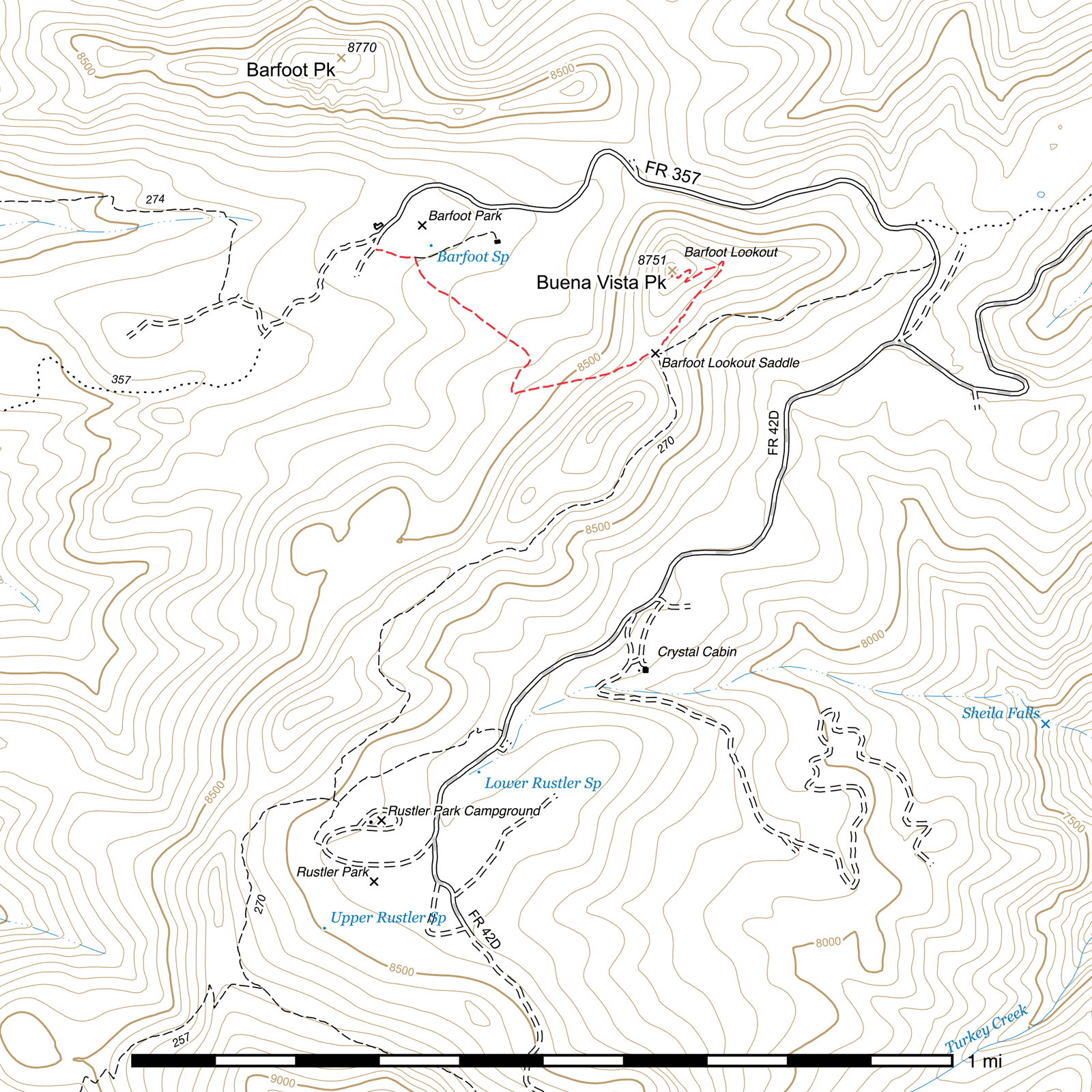
The lower terminus is at the southwest corner of the meadow at Barfoot Park, starting immediately outside the corner fencepost. There is a trail sign which marks this spot, though it does not identify the trail by name. (31.91697, -109.27995)
The Crest Trail intersects the trail at Barfoot Lookout Saddle, (31.91479, -109.27410) which can be easily accessed from either the northern terminus of the Crest Trail 0.4 mile northeast along the Barfoot Park Road (FR 357), (31.91691, -109.26827) or from Rustler Park 0.9 mile southwest via the same trail.
History
Buena Vista Peak, which this trail climbs to the top of, was the site of a Model L-4 fire lookout cabin built by the Civilian Conservation Corps in 1935 which remained in partial operation until it burned to its foundation in the 2011 Horseshoe 2 fire. Fire crews wrapped the structure in fireproof material, but extremely high winds and intense heat caused it to be lost in spite of the efforts to save it.1
Trail Description
Barfoot Park to Crest Trail
- 0.51 mi
- 400 ft ↑
- 14.9% slope
From just outside the fence at the southwest corner of Barfoot Park, (31.91697, -109.27995) this trail begins roughly to the east for nearly 300 feet before angling sharply to the right. (31.91678, -109.27907) The Harper Trail continues along the southern edge of Barfoot Park for a short distance from this point. Immediately after the turn, the trail begins to climb, albeit gradually at first. This stretch of the trail is under tall pines which were largely undamaged by fire, and the ground is covered with needles. Rocks line both sides of the trail to mark the route.
After 1000 feet in a roughly straight line, the trail curves to the right, entering a thicket of aspen saplings. (31.91475, -109.27673) The trail may be obscured in places in this area. In 350 feet, it bends again, sharply to the left this time, (31.91396, -109.27707) and begins climbing the last 1000 feet in a straight line up to its eastern terminus at Barfoot Lookout Saddle, (31.91479, -109.27410) with no switchbacks. Flooding can cause this stretch of the trail to wash out in places, or debris from above to fall on it. Aspen saplings may be growing in the trail as well if it hasn't been maintained recently.
From the saddle, you have a choice of four different routes. The Barfoot Lookout Trail climbs the rest of the way to the top of Buena Vista Peak, where the foundation of the former Barfoot Fire Lookout cabin can be seen and a great view of the surrounding area enjoyed. Alternatively, the Crest Trail passes through this saddle in two directions. The northern segment can be taken to drop back down to the Barfoot Park Road (FR 357) and loop back around to Barfoot Park, while the southern segment will take you to Rustler Park and destinations beyond. Finally, if you're feeling adventurous, the old fire lookout shortcut route can be pieced together heading straight up the ridge to the lookout.
Crest Trail to Barfoot Lookout
- 0.28 mi
- 180 ft ↑
- 12.2% slope
The trail leaves Barfoot Lookout Saddle (31.91479, -109.27410) heading north-northeast and continues in a straight line, steadily climbing for the next 0.16 miles, before switchbacking to the southwest for 300 feet. This entire area was heavily burned in the 2011 Horseshoe 2 fire, and many of the large pine trees that once shaded these slopes are dead. Four additional switchbacks follow, each closer than the previous as the trail approaches the top of Buena Vista Peak. An unusually shaped tree near the peak, resembling a football goalpost, is still standing but now dead. After making the second to last switchback, the cistern and foundation of the Barfoot Lookout's outhouse can be seen. At the very top, the lookout's own foundation stands, (31.91651, -109.27375) with broken glass and other debris in the middle. Although the lookout no longer remains, a fantastic view of Barfoot Peak and Park, and the greater area in general, can be had here. Cochise Head lies roughly to the north and can be clearly seen from this angle. A radio repeater and solar panel have been installed at the top of Buena Vista Peak near the ruins.
Map
Footnotes
- http://www.gvrhc.org/Library/BarfootFireLookout.pdf
Last updated July 12, 2025.