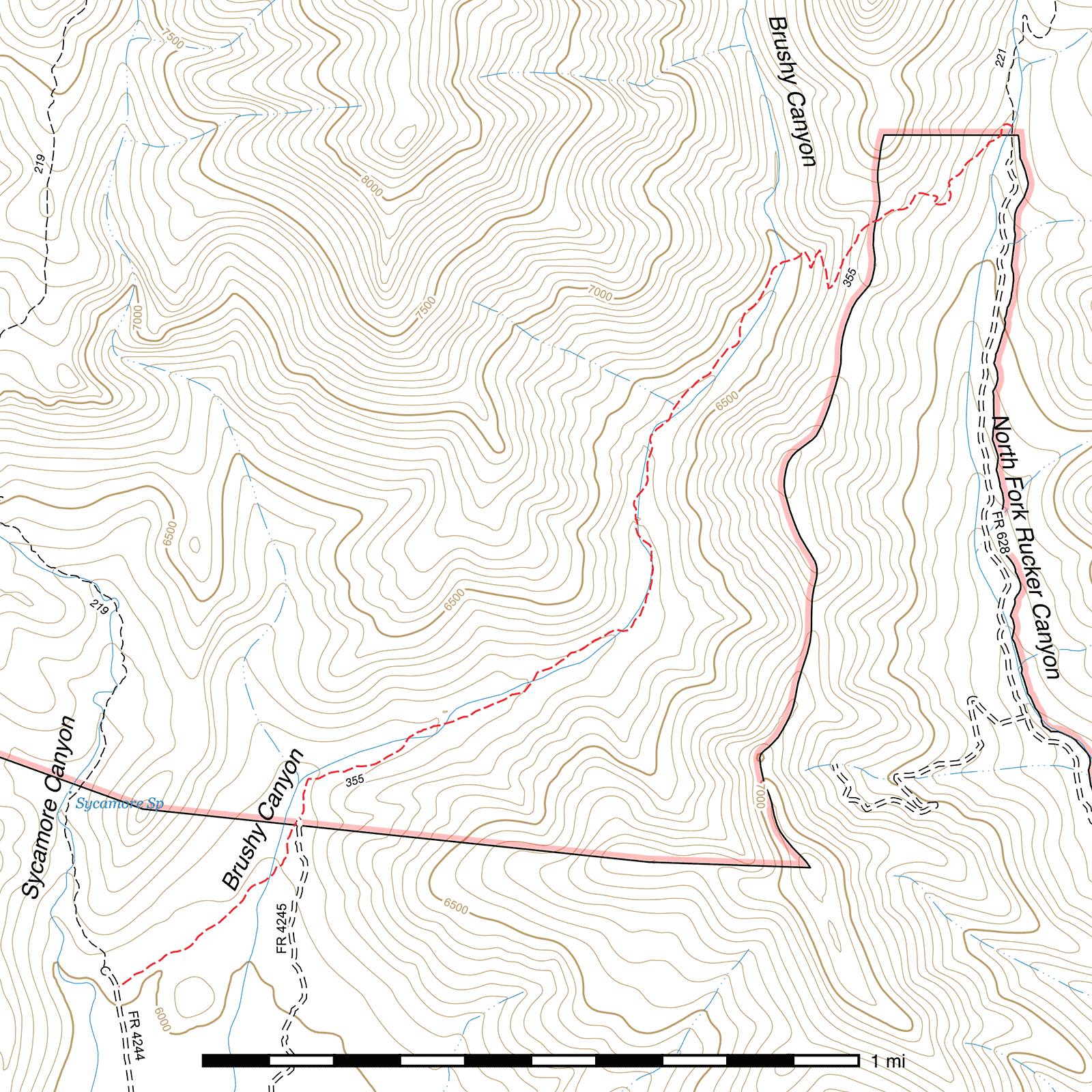
Brushy Canyon Trail #355
Important Note
This trail traverses the Brushy Canyon north of Rucker Canyon, not to be confused with the Brushy Canyon southeast of Price Canyon.
Current Conditions
The western portion of this trail was cleared and improved in places by Wild Arizona's Youth Conservation Corps in July 2023, but work did not make it out of the riparian portion, and extensive flood damage remained near creek crossings despite some repairs and marking.
Length: 2.53 mi
Difficulty: moderate
Condition: bad
Elevation range: 6030 ft – 6780 ft
Access
The Brushy Canyon Trail can be accessed from three locations.
The southwestern terminus (31.77810, -109.34289) is on the east side of Sycamore Canyon Road (FR 4244), 150 feet before the turnaround loop at the end of the road and the trailhead of the Turtle Mountain Trail. There are two signs here, one for the Turtle Mountain Trail and a broken, fallen over Carsonite sign—currently with only the trail number "355"—for the Brushy Canyon Trail.
0.43 mile from the southwestern terminus, the Brushy Canyon Road (FR 4245) connects to the trail at a small campsite. (31.78242, -109.33815) This location is not signed, but there is a wooden post at the end of the road and a Wilderness boundary sign 30 yards north-northeast along the trail.
The northeastern terminus (31.80040, -109.31965) lies along the Monte Vista Trail just past where it leaves the end of North Fork Rucker Canyon Road (FR 628). This junction is not marked by a sign, but there are rock cairns.
Trail Description
Sycamore Canyon Road to Brushy Canyon Road
- 0.43 mi
- 80 ft ↑ 20 ft ↓
- 2.6% slope
Heading northwest from the trailhead, the Brushy Canyon Trail begins with a very gradual descent through oak scrub, then begins climbing soon after crossing a small drainage. During the steepest part of the short ascent, the trail bypasses to the left of some erosion damage. 0.15 mile after the trailhead, you will cross an old fenceline with a gate the trail once passed through but now diverts to the right of. (31.77933, -109.34080)
Now paralleling the fence, the oak cover gets thicker as the trail maintains its northeastern heading. After another 0.19 mile, it briefly travels alongside Brushy Creek before curving to the right and crossing it. (31.78123, -109.33868) Note that minor flood damage has made it slightly difficult to recognize this crossing and animals have been missing it and walking along the west bank, making it look as though the trail continues when it does not.
After crossing, continue northeast a short distance before arcing north-northeast. 480 feet after crossing Brushy Creek you will come to a small clearing with a fire circle. The Brushy Canyon Road connects in from the south here. A wooden post marks this junction, but there is no trail sign. (31.78242, -109.33815)
Brushy Canyon Road to Last Creek Crossing
- 1.43 mi
- 390 ft ↑ 5 ft ↓
- 5.1% slope
Continuing north-northeast out of the clearing, the Brushy Canyon Trail passes a Wilderness boundary sign after 90 feet (31.78265, -109.33804) before turning nearly due north. Another 220 feet and the trail appears to disappear completely into flood damaged Brushy Creek. (31.78324, -109.33799) Don't worry, though, it's only for a short distance: walk upstream 100 feet and you should be able to clearly see it exiting the creek and heading due east. (31.78348, -109.33788)
Climbing onto a slightly higher bank and traveling away from the creek a bit, the trail continues to pass through a healthy oak forest (with occasional catclaw acacia encroaching on the trail in places—the only aspect of this trail that resembles its name). Shortly after it begins to curve back to the northeast. ⅕ mile after leaving the creek, you will come to another crossing. (31.78471, -109.33505) This one is straightforward and goes right across to the other side, but flooding has cut the creek deeper than it once was, so there is currently a bit of a step down and back up.
You'll head northeast only 240 feet before crossing the creek again. This one is even more straightforward, with the trail clearly visible on the other side. (31.78492, -109.33437) Climbing somewhat steeply for approximately 150 feet, it emerges back onto a flat bank somewhat higher than at previous points along the trail, but it's back to the creek and another crossing again in 700 feet. (31.78607, -109.33207) The next 900 feet of trail is fairly straightforward, although be careful of animal paths and bypasses around fallen trees. As you approach the creek again, a cattle path can be very misleading and makes it appear the trail continues to parallel instead of crossing the wide, rock rubble-filled creekbed. Watch for a trio of rock cairns to mark this crossing, one on each side and one on a raised area in the middle. (31.78734, -109.32980) Also note that many maps incorrectly show the trail staying on the west side of the creek here instead of crossing.
For the next 450 feet, the trail stays close to the creek on its east side before they start to drift apart again. Another 350 feet and you'll pass two cattle drinkers, one made from an old water heater tank, just off the trail in a small clearing. (31.78919, -109.32902) Still loosely paralleling the creek, but a bit further away than earlier, you'll continue generally north-northwest for 550 feet before coming to another crossing. (31.79055, -109.32945)
Approximately 0.17 mile later, the trail begins to climb up a slight incline and briefly fades in the grass growing on the slope. (31.79278, -109.32862) Continue north-northeast up the slope and you'll pick up the trail again on the downhill side where it's clearly cut into the sideslope for a short section before returning to the flat. Be careful in this area, especially heading in the reverse direction, as there is a fork here with a short spur running down to a lower level above the creek. The upper fork is the main trail. Consider a trip down the lower fork, however, to a nice segment of exposed bedrock in the creek bottom, and a possible place to get water certain times of year. (31.79286, -109.32834) The main trail continues north-northeast on the northwest side of Brushy Creek for 0.32 mile, arcing northeast at the end to cross one final time. (31.79689, -109.32558) There is more exposed bedrock where water is sometimes available if you continue off-trail approximately 0.1 mile up the creek bottom.
Last Creek Crossing to Monte Vista Trail
- 0.67 mi
- 320 ft ↑ 200 ft ↓
- 3.4% slope
Heading northeast away from the final crossing with Brushy Creek, the trail climbs gradually for 200 feet before coming to the first of a set of four switchbacks. (31.79716, -109.32505) The trail is quite narrow in places for the next 0.14 mile, and occasionally very steep and slippery, so be careful. After the fourth switchback, (31.79620, -109.32438) you'll be heading northeast yet again in the final, more gradual, 0.14 mile push to a saddle between Brushy Canyon and North Fork Rucker Canyon. (31.79795, -109.32319) Great views of both canyons, and of the slope of Turtle Mountain to the west-northwest. This saddle is also the Wilderness boundary, though it is not marked by a sign.
Now descending, the northwestern course that has dominated this trail continues. After 450 feet, there is a turn to the east with a steeper descent for 175 feet, followed by a pair of switchbacks and a curve back around to the northwest after. It's ⅕ mile from the second switchback down to the crossing of North Fork Rucker Creek (31.80046, -109.31978) which can be faint to see but heads east-southeast. It's only another 45 feet to the northeastern terminus along the Monte Vista Trail. (31.80040, -109.31965) There is no sign or marker here indicating the Brushy Canyon Trail connects in at this spot unless rock cairns are present. It's only 320 feet south from here to the end of the North Fork Rucker Canyon Road (FR 628).
Map
Last updated July 13, 2025.