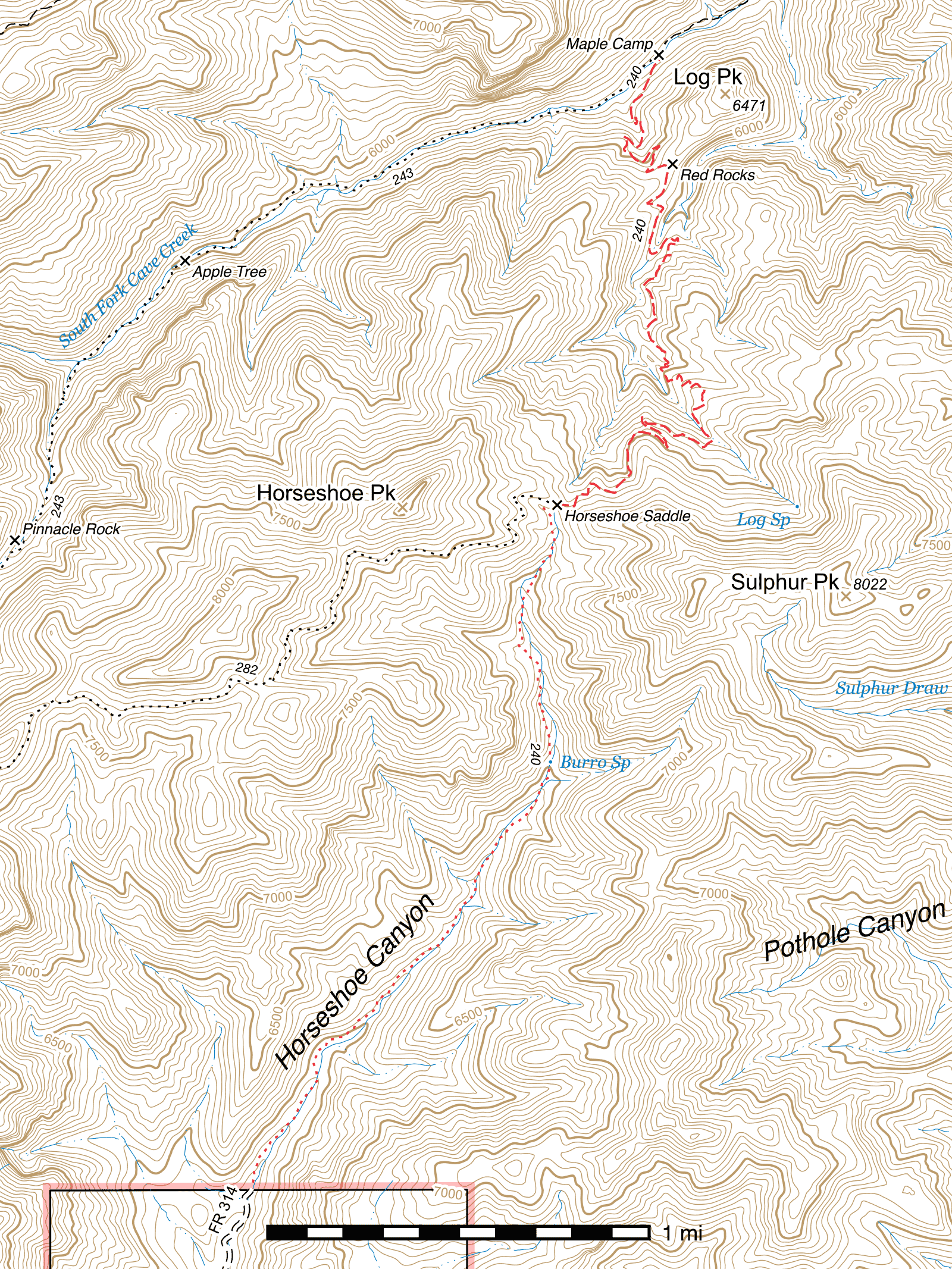
Burro Trail #240
Important Note
Because this trail goes up and over a ridge, its average slope is misleading. Refer to the elevation gain/loss and segment-level slope for a more accurate indication of its steepness.
Current Conditions
As of July 2022, the Burro Trail is in mostly good condition from the South Fork Trail to Horseshoe Saddle. There are several spots where tread is narrow, but it's quite passable and easy to follow. Close to Horseshoe Saddle, there are several short tread blowouts, one of which can be somewhat precarious to cross at present. Horses are not recommended on this trail above the second Log Canyon crossing due to several obstructions and narrow sections.
On the Horseshoe Canyon side of the saddle, things have not been maintained for a very long time and conditions are poor to nonexistent. The road at the Horseshoe Canyon end of the trail is also destroyed and not passable by vehicle for a number of miles.
Length: 5.56 mi
Difficulty: moderate
Condition: good
Elevation range: 5600 ft – 7225 ft
Access
The Burro Trail is accessible from three locations.
The northern terminus is located 2.08 miles up the South Fork Trail, at Maple Camp. (31.84973, -109.19829) This junction is marked with a sign. The Burro Trail begins on the south side of the trail and immediately crosses the South Fork of Cave Creek before climbing onto dry land again.
The highest point at Horseshoe Saddle is accessible via the Horseshoe Ridge Trail, which drops down from the southwest. The signs at this junction have rotted and are lying in pieces on the ground, largely unreadable. There is a somewhat overgrown clearing at the saddle, and the Horseshoe Ridge Trail enters the northwestern corner of this. (31.82978, -109.20301)
The southern terminus begins at the wilderness boundary at the end of Horseshoe Canyon Road (FR 314), 8.5 miles beyond the National Forest boundary. (31.79923, -109.21650) This road was heavily damaged by Hurricane Odile in September 2014, but as of April 2015 has been partially repaired and reopened to motor vehicles. High clearance vehicles are necessary, 4WD is required, and the road no longer continues to the Burro Trail trailhead, ending just beyond Blevins Draw.
Trail Description
Maple Camp to Red Rocks
- 0.74 mi
- 535 ft ↑
- 13.7% slope
From the signed junction with the South Fork Trail at Maple Camp, (31.84973, -109.19829) the Burro Trail immediately crosses the South Fork of Cave Creek and begins climbing out of the canyon. After 700 feet, passing through a fire-damaged portion of forest, the trail swings around to the left, into a small side canyon. At this bend, in spite of the burned trees, there is a great view of the red rhyolite cliffs across and further up the canyon.
The first switchback occurs 500 feet later, followed by a series of several more switchbacks as the trail climbs and crosses a small drainage twice. About 0.36 mile after the first switchback, the trail begins to enter an area of red dirt and rocks, and this persists for the remaining 800 feet to the ridgetop. Large red rocks on the north side of the trail provide a fantastic lunch or break spot, with a spectacular view into Log Canyon below. (31.84486, -109.19796)
Red Rocks to Horseshoe Saddle
- 2.28 mi
- 1145 ft ↑ 55 ft ↓
- 9.1% slope
The trail heads south from Red Rocks, immediately beginning to descend into Log Canyon. After 700 feet, it crosses a side drainage and angles east for 250 feet, before turning south again for another 800 feet to the Log Canyon drainage crossing. (31.84098, -109.19869) It begins climbing the eastern slope of Log Canyon, heading roughly north for 350 feet before swinging back east and then south. (31.84167, -109.19750) Frequent side drainages cause the trail to contour with the terrain extensively through this area.
0.32 mile after the trail resumes its southerly course following the first Log Canyon crossing, a very narrow point in the trail is encountered. (31.83805, -109.19844) This had been badly washed out down and dangerous to cross, and extensive repairs have been done from 2012 to 2022. Caution is still advised, as it remains a narrow passage across rock, with a steep drop to one side. Equestrians may consider not continuing past this point, or leading their horse. From this point, the trail continues up a side canyon for 900 feet before several switchbacks over a 250 feet stretch take you back to a ridge above Log Canyon. Several additional, more gradual switchbacks continue up that ridge for 1000 feet before the trail drops down into Log Canyon 960 feet later for its second crossing. (31.83309, -109.19640)
Now on the other side of the creek, the Burro Trail swings to the west and begins to climb again to a pair of long switchbacks. The second switchback, 0.36 mile after the crossing, has a fork where an unofficial shortcut heads east. (31.83233, -109.19794) Care must be taken at this point when approaching from either direction to not miss the correct turn. The trail exits this switchback heading northwest and gradually swings around a ridge until it's going south again. The final 0.53 mile to Horseshoe Saddle can be quite narrow and slippery in places, with steep drops to one side, as it contours in and out of side drainages.
The trail enters the clearing at Horseshoe Saddle at its northeast edge. (31.82976, -109.20288) There is a fantastic view from here of the route you took up to this point, as well as of Silver Peak and Mount Sceloporus beyond, and Horseshoe Canyon in the other direction. Most of the signs here have rotted and are unreadable. The Horseshoe Ridge Trail leaves from the northwest edge of the clearing. (31.82978, -109.20301) The Burro Trail continues down into Horseshoe Canyon at the southern edge. (31.82961, -109.20297)
Horseshoe Saddle to Horseshoe Canyon Wilderness Boundary
- 2.54 mi
- 1370 ft ↓
- 10.2% slope
Dropping into the very upper end of Horseshoe Canyon, the trail heads west for 160 feet until it reaches the canyon bottom, which it crosses and then continues along just above after swinging south. (31.82961, -109.20347) The next 500 feet remain fairly exposed on the west side of the drainage, then it crosses back to the east side and shortly after enters tree cover. The next 0.77 mile to Burro Spring alternate between periods of the trail being visible and easy to find, and other periods where it is completely obscured under debris from flooding. Little evidence of Burro Spring is visible—a small puddle of muddy water may present nearby if you're lucky. (31.81831, -109.20317) The remaining 1.63 miles to the Wilderness boundary is similarly obscured much of its length. (31.79923, -109.21650)
Map
Last updated July 13, 2025.