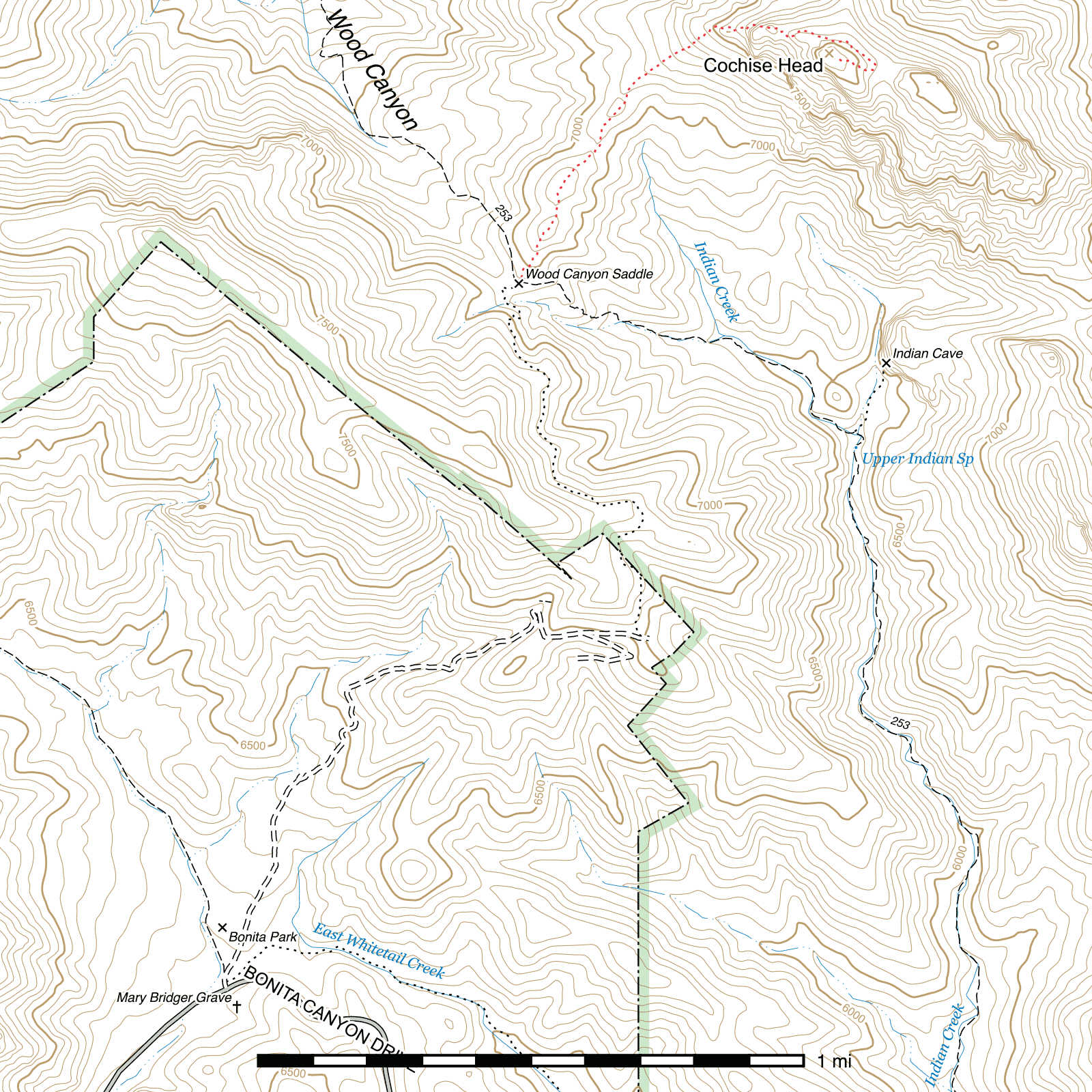
Cochise Head Route
Length: 1.19 mi
Difficulty: expert
Condition: terrible
Elevation range: 6985 ft – 8080 ft
Access
The Cochise Head Route is accessible via Wood Canyon Saddle, (32.05210, -109.30962) at a junction between the Indian Creek Trail and the Horse Trail out of Chiricahua National Monument. This junction is signed, but the signs burned in 2011 and are difficult to read.
Trail Description
From Wood Canyon Saddle, (32.05210, -109.30962) head roughly northeast along the ridge. Hiking directly along the heavily burned ridgetop itself is the easiest for navigation purposes but requires ascending and descending three separate small hills, so it may be preferable to contour around the sides of each of these to reduce the amount of climbing necessary here. There are numerous cattle paths through this stretch, and no distinct human trail.
After half a mile, you should reach a saddle (32.05818, -109.30617) at the north end of the third small hill and be faced with a steep slope climbing to around the base of Cochise's chin. Rock cairns begin marking the general route along here, and it pays to stick close as they'll guide you to where the more distinct trail picks up ahead. 0.2 mile of very steep and hot climbing follows, after which (32.06003, -109.30364) you should be a little over 100 feet to the west of a large rock outcrop disconnected from the main Cochise Head formation. Angle to the east here, following the cairns and frequently climbing steeply. There are occasionally several different faint trails through here, but you want to head for the north side of Cochise's chin, about 500 feet away. (32.06015, -109.30238)
The trail skirts along the rock cliff here, heading east, and the area opens up somewhat after about 150 feet, usually providing a good place to rest in the shade as well as a wide open view north towards San Simon and the Peloncillo Mountains Wilderness. While the south side of Cochise Head was hit hard by fire, the north side was not as heavily burned and there are still pine and aspen and a large number of Gambel oak. 100 feet beyond, a small cave lies on the south side of the trail. (32.06001, -109.30154) Another steep climb, angling to the southeast, and you should emerge at a saddle of sorts between the chin formation and a large rock spire. (32.05983, -109.30124) The cairn-marked route will guide you around the south side of the spire and back up steeply to another saddle between that spire and Cochise's lips. (32.05982, -109.30110)
From here, you will drop down to the northeast into a scree field. After about 100 feet, towards the bottom of the field, the trail swings back to the east-southeast. Falling rock has caused damage to the trail over the next roughly 350 feet and you will have to pick your way over the scree, following cairns as you find them. Eventually, the trail picks back up again (32.05969, -109.29986) and you can follow it easily for about 175 feet until it passes through a stretch of Gambel oak overgrowth. There is a bypass that forks off near here as well, but it climbs high before dropping right back down. Once through the oak, (32.05946, -109.29922) the trail is clearly visible for the next 300 feet as it descends through and out of the scree field, approaching a saddle between Cochise's eyebrow and nose. You can follow the trail for another 60 feet or so as it turns to the south, (32.05877, -109.29853) then it fades for the final 500 foot stretch climbing to the high point at the top of the nose. Head west-northwest and pick your way up the steep slope. A series of rock cairns arranged roughly in a triangle marks the peak, (32.05928, 109.29992) and a summit register is in a bottle under some rocks nearby.
Map

Last updated July 13, 2025.