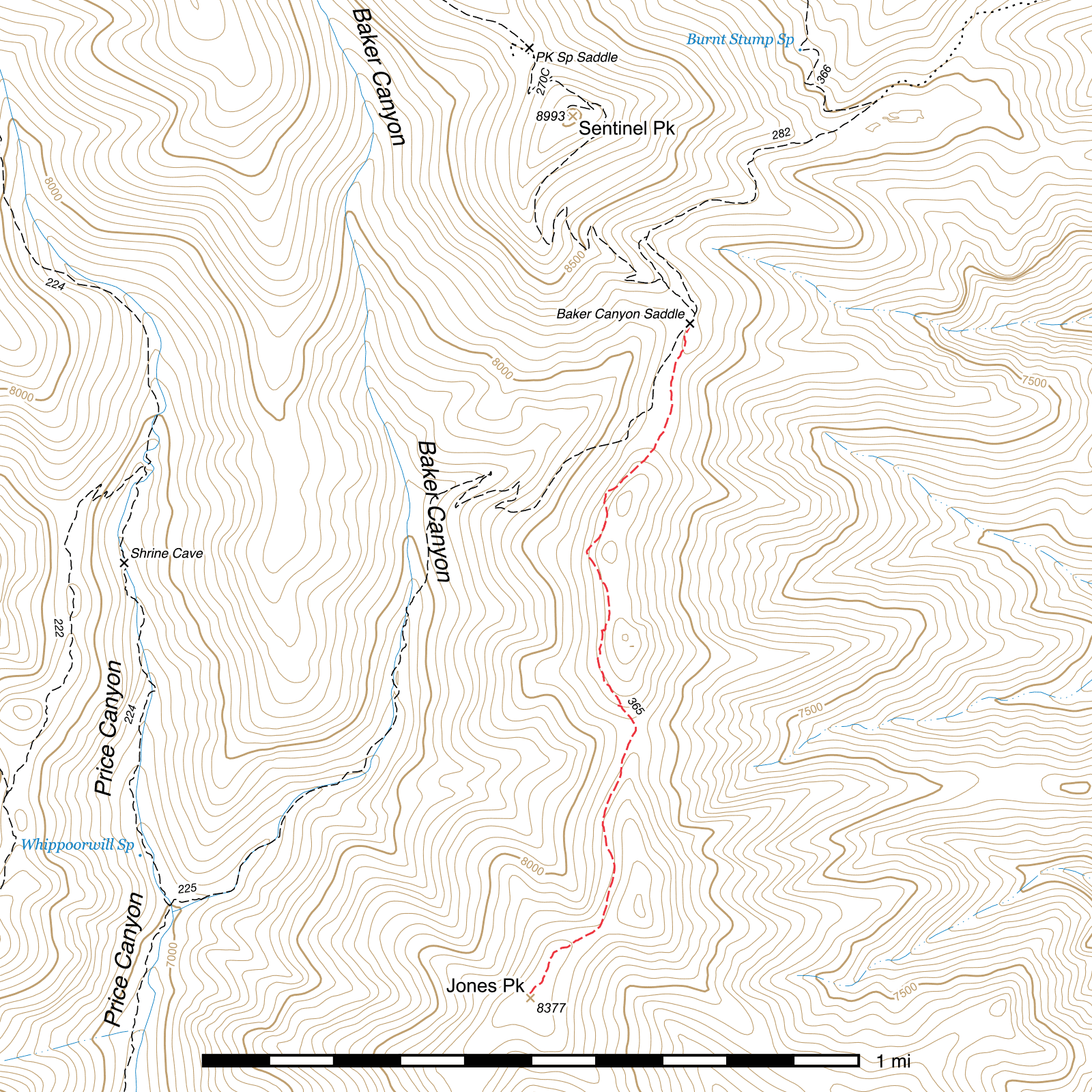
Jones Ridge Trail #365
Current Conditions
This trail has not been surveyed since 2014.
Length: 1.39 mi
Difficulty: moderate
Condition: bad
Elevation range: 8140 ft – 8380 ft
Access
The Jones Ridge Trail is accessible from a single point along the Baker Canyon Trail. From the upper terminus of the Horseshoe Ridge Trail, (31.80858, -109.23956) which is roughly marked by a burned sign, walk south-southwest for 100 feet. (31.80833, -109.23969) Here, the Baker Canyon Trail drops away to the right while the Jones Ridge Trail continues out along the spine of the ridge to the left. The signs at this junction have nearly completely burned, but you can still see the short stubs of two pairs of signposts sticking out of the ground.
History
Jones Ridge is named after Lawrence Jones, a 17 year old boy who became lost and died in the nearby cliffs while on a fire crew April 20, 1923.
Trail Description
From Baker Canyon Saddle, the Jones Ridge Trail takes the left fork and stays atop the ridge of the same name, heading south-southwest, while the Baker Canyon Trail descends away along the right fork. After just under ¼ mile of somewhat faint trail, there is a false fork, with an unofficial route to the left continuing up the now much steeper ridgetop. (31.80506, -109.24062) Stay to the right, on the fork that more gradually climbs southwest along the western side of the ridge. The trail remains faint here, but is defined enough to follow.
Another 0.11 mile and you will come to a bend in the trail beneath a rock outcrop (31.80396, -109.24186) and turn roughly south, continuing to contour along the western slope of Jones Ridge for the next 0.12 mile, curving southwest again for a short time and then coming to another, sharper bend to the southeast. (31.80241, -109.24237)
Around here, the trail quality degrades significantly for a time. There may be remnants of flagging tape or rock cairns to help guide your way through here, but continue southeast, gradually curving south until you pick up fragments of trail again in a few hundred feet. About 600 feet after it starts to reappear, you will come to some faint remnants of about four switchbacks where the trail descends to bypass a rock outcrop. These are faint and not entirely defined anymore, but do appear to be manmade. (31.80037, -109.24191) Continue south out of the switchbacks for about 250 feet before curving southeast again. This area is very overgrown with manzanita, but descend towards the saddle ahead of you (31.79785, -109.24110) and you should pick it up again a short distance before reaching it. Watch out for the rock formation just off trail above this saddle, which has walls on three sides and can provide shelter from the wind, as well as having a window out the back side.
From the saddle on, the trail is quite clear again. It turns south-southwest and starts climbing towards Jones Peak. After 0.37 mile, you'll come to another saddle with a large rock cairn. (31.79268, -109.24203) A prominent looking peak is to the northeast of the saddle, but Jones Peak is the more rounded one to the southwest. Continue up the ridge in that direction, following cairns and the mostly-visible path. It's another 0.19 mile from the saddle to the top of the peak. (31.79093, -109.24367) The summit is nicely forested and wasn't heavily burned by the 2011 Horseshoe II fire. Good camping can be found here, though there are no water sources nearby, so be sure to pack in all you need.
An epic viewpoint into Horseshoe, Jack Wood, Brushy, Price and Rucker Canyons can be found another 0.3 mile southwest at the end of the ridge, though the trail proper does not continue out that far. (31.78729, -109.24567)
Map
Last updated July 14, 2025.