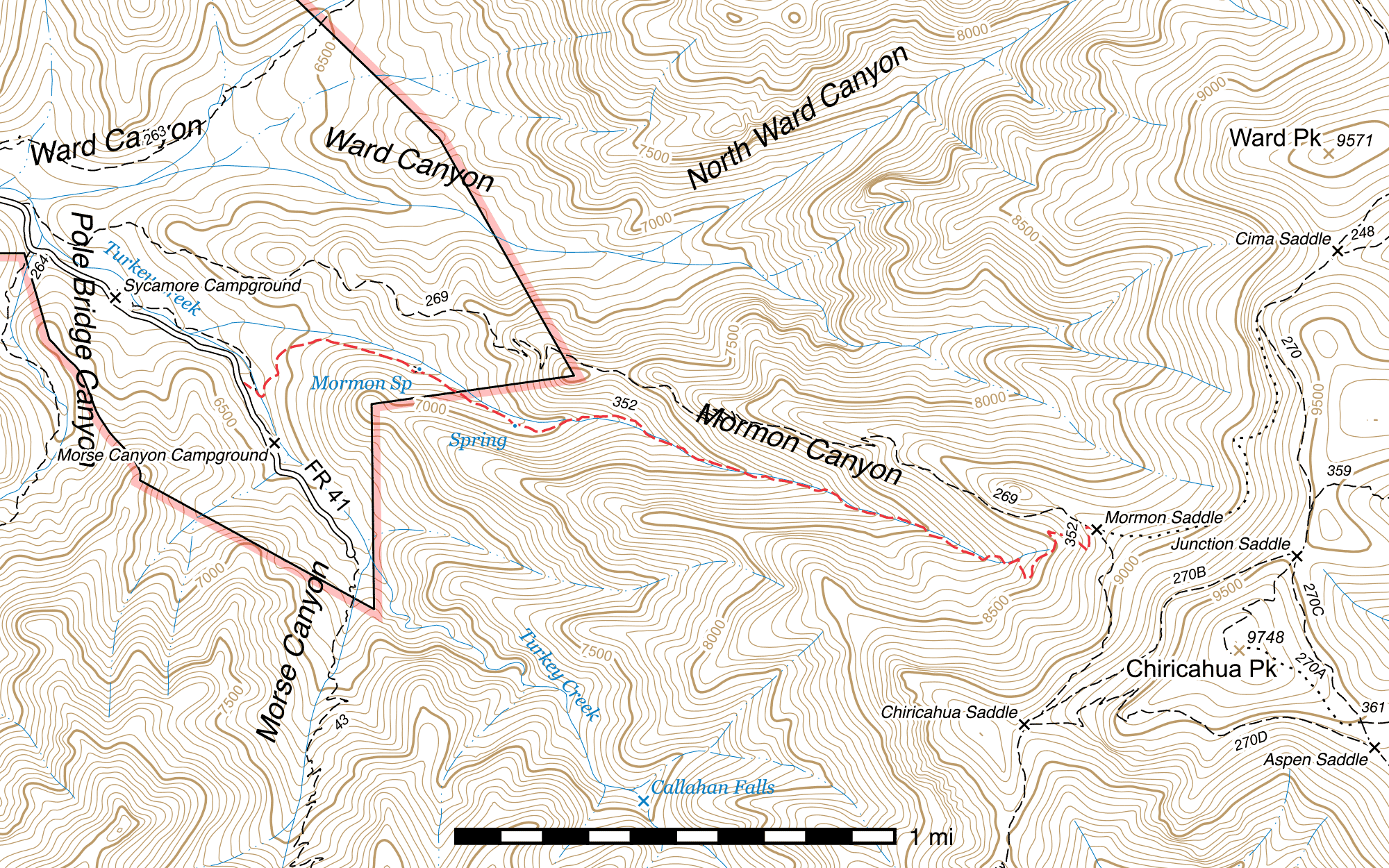
Mormon Canyon Trail #352
Current Conditions
This trail was cleared of deadfall and numerous creek crossings redefined and repaired in September 2022 by Wild Arizona's Wild Stew Field Crew, but has not been surveyed since.
Length: 2.57 mi
Difficulty: moderate
Condition: moderate
Elevation range: 6370 ft – 8755 ft
Access
The Mormon Canyon Trail is accessible from three locations.
The lower elevation western terminus lies at a signed trailhead with single car pull-off (31.85624, -109.32990) on the east side of the Turkey Creek Road (FR 41), ⅖ mile southeast of Sycamore Campground.
If you are starting from Sycamore Campground, you can cross the creek on the east side of the campground (31.85929, -109.33397) and walk roughly the same distance up an older, more shaded logging road on the north side of the creek, passing a gate (31.85863, -109.33239) and a waterfall (31.85827, -109.33211) along the way. You will connect to the Mormon Canyon Trail 200 feet southeast of its official trailhead along Turkey Creek Road. (31.85603, -109.32931)
The higher elevation eastern terminus is at Mormon Saddle, (31.85061, -109.29674) where it connects with the Mormon Ridge Trail and the abandoned Upper Mormon Ridge Trail cut-off. This junction can be somewhat faint, and the Mormon Canyon and Mormon Ridge trails parallel each other closely for 100 feet. Mormon Canyon is the southernmost of the two trails exiting the saddle to the west.
History
The ruins of a historic sawmill can be found close to the Wilderness boundary. (31.85564, -109.32097)
Trail Description
Trailhead to Mormon Spring
- 0.54 mi
- 320 ft ↑ 10 ft ↓
- 10.9% slope
From Turkey Creek Road (FR 41), the Mormon Canyon Trail departs a signed junction and drops to Turkey Creek itself, crossing it after 150 feet. 50 feet beyond, the trail connects to the alternate route from Sycamore Campground, (31.85603, -109.32931) which heads northwest, while the Mormon Canyon Trail heads southeast. Over the next 0.1 mile the trail describes a U and climbs out of the drainage, heading north, then swinging eastward. An old logging road connects from below, (31.85662, -109.32841) and the trail continues atop this road for a while as it crosses the ridge dividing Turkey Creek and Mormon Creek. After another 0.17 mile it begins to parallel Mormon Creek on its south side, where it remains for the 0.23 mile to Mormon Spring.
The spring is not marked by a sign, but there is a small cut-off trail (31.85673, -109.32314) heading northeast for 75 feet to the actual spring site. (31.85684, -109.32297) The area below the spring is often very thick with lush plant life and can be seen from the main trail. An old cement trough, no longer connected to the spring, lies 80 feet to the northwest along a faint path. (31.85694, -109.32321)
Mormon Spring to Mormon Saddle
- 2.03 mi
- 1985 ft ↑ 10 ft ↓
- 18.4% slope
150 feet southeast beyond the Mormon Spring spur a beautiful, massive oak tree—one of the largest in the canyon—can be seen on the north side of the trail. (31.85664, -109.32265) A little over a tenth of a mile later, the trail and the old logging road part ways, (31.85569, -109.32114) the trail forking to the right while the road goes left for 50 feet to the site of an old sawmill where a foundation still remains. (31.85564, -109.32097) The Wilderness boundary is a short distance past this fork.
The trail beyond here is not always in the best condition, as it stays close to and frequently crosses the creek, where flooding has occurred. The surroundings, however, are beautiful—lush forest with moss-covered trees and rocks. A small seep can be found on the south side of the trail 0.13 mile above the sawmill junction. (31.85464, -109.31927) After another 0.35 mile, the creek disappears under gravel and rock and generally does not reappear unless there has been recent rain or snowmelt.
For the next 0.78 mile, the trail alternates between reasonably good and quite bad as it moves back and forth across the creek and climbs up the canyon. In places, the trail has partially collapsed into the flooded canyon bottom, and other times it disappears entirely, requiring you to walk across rocky rubble for a while until you can pick it up again. Finally, it climbs the north bank and crosses through a steep, eroded stretch marked largely by frequent rock cairns for 0.17 mile, before climbing even more steeply through a series of six switchbacks across 0.45 mile to reach Mormon Saddle, (31.85061, -109.29674) its upper terminus and junction with the Mormon Ridge Trail. To the left you can follow Mormon Ridge 3.51 miles back down to Turkey Creek Road (FR 41), while Chiricahua Saddle along the crest-trail-270b is 0.59 mile to the right. The abandoned Upper Mormon Ridge Trail can be faintly seen heading east out of Mormon Saddle. This junction is marked with two signs, one of which is now missing.
Map

Last updated July 14, 2025.