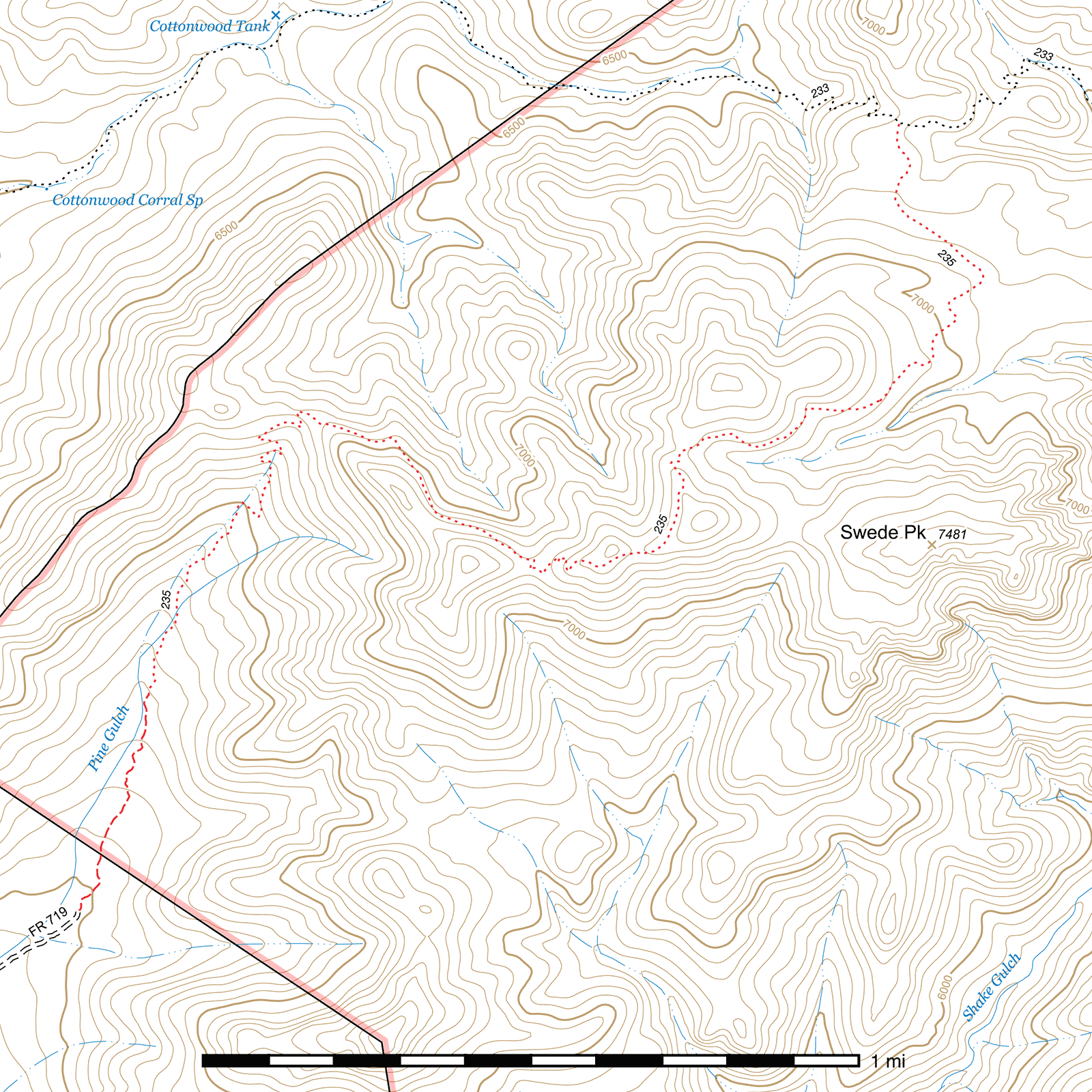
Pine Gulch Trail #235
Current Conditions
As of May 2017, the first ½ mile through the burned and overgrown area at the start of the trail has been brushed, and it has been flagged to the ridge at the top of the switchbacks. Conditions beyond are still rough and overgrown, but progress to clear and reopen the start of the trail continues.
Length: 3.21 mi
Difficulty: difficult
Condition: bad
Elevation range: 5970 ft – 7365 ft
Access
The Pine Gulch Trail is accessible from two locations.
The lower-elevation southern terminus is located at the end of the 1.8 mile long Pine Gulch Road (FR 719). From Highway 80, take Tex Canyon Road (FR 74) 9.5 miles to a signed junction with FR 719. (31.69340, -109.32919) FR 719 is a very rough road in places and should only be attempted in a high clearance vehicle, and you may wish to park before reaching the end of the road and walk the remaining distance. The trailhead is not visibly marked, but a Wilderness boundary sign is effectively the end of the road and beginning of the trail. (31.71502, -109.31820)
The higher-elevation northern terminus is at a three-way junction with the Cottonwood Trail. The signs here have rotted and are lying in pieces, unreadable, but several large cairns mark the spot and roughly indicate the three directions in which trails depart. (31.73534, -109.29697)
Trail Description
The Pine Gulch Trail departs from the end of FR 719, (31.71493, -109.31824) heading roughly north-northeast. The first half mile of this trail passes through fire damaged terrain and has only very intermittent and brief tree cover, with young oak and manzanita growing alongside the trail. Rock cairns, old blazes on trees, and flagging tape can help keep you on track if you get turned around, but as of May 2017 much of this trail corridor has been cleared and redefined. The trail stays on the east side of the (usually dry) creekbed, crossing side drainages twice. Eventually you will reach a point where the tread becomes much more clear and remains so, though it hasn't been maintained for some time and brush is encroaching upon the trail in places. Approximately a tenth of a mile after this, you will enter a nice patch of unburned pines (31.72305, -109.31567) and, while you'll pass through occasional burned areas, it will remain largely unburned for the climb to the saddle above.
Two tenths of a mile after entering the unburned pines, the trail makes its first switchback, marked by a metal signpost—a wooden sign (stating "TRAIL" with an arrow pointing to the right) has fallen to the ground below . From here, the trail begins climbing in earnest, hitting another switchback 200 feet later and, 550 feet after that, it enters a series of 6 switchbacks to a saddle over a two tenth mile stretch. Good views of Pine Gulch, Tex Canyon with Limestone Mountain behind, and Sunset Peak can be enjoyed to the south as you stop to catch your breath on the way up.
At the saddle, the trail enters a large area of heavy fire damage which it remains in for the remainder of its length. There is a good view to the north of a side canyon off Cottonwood Canyon, as well as the Chiricahua Crest, including—if you look closely enough—the Monte Vista Peak fire lookout.
At this point, the terrain becomes much more rugged—in part due to the fire damage, which has caused some erosion, though the trail remains in reasonably good condition here considering. Heading east out of the saddle on a steep slope, already high above the canyon below, you'll climb at a relatively steady rate to a second saddle half a mile ahead. After 850 feet you'll contour around a small protrusion in the terrain and angle further to the southeast. Some additional minor contouring occurs in the next third of a mile as you pass along the north slope of a minor unnamed peak. (Note that many maps incorrectly show the trail passing south of this hill.) You'll then make a switchback and climb to the second saddle.
The trail heads east-southeast across the second saddle for 120 feet and makes another switchback to the north. Four more switchbacks occur over the next 450 feet as it climbs another unnamed peak along the ridge, skirting around it to the right. A minor saddle is crossed 650 feet after the fourth switchback, after which you will angle gradually to the north, keeping west of a third small peak before dropping to a fourth saddle—a couple switchbacks along the way—a quarter mile after the third. Your first good view of Swede Peak and its spectacular red and yellow rock cliffs can be had from around here.
From the saddle the trail continues descending along the southeastern slope of another small peak, on the west side of a minor canyon that separates you from Swede Peak. 300 feet after leaving the saddle, there is a reasonably good approach to the peak before the canyon gets too deep. The view from the top down into Shake Gulch 2000 feet below to the east is incredible.
The next third of a mile is a continuation of the same, gradually descending along the western edge of the canyon. As it rounds the eastern edge of the aforementioned peak, however, it disappears almost entirely. Fire hit this area quite hard and obliterated evidence of the trail at the same time. To follow the general route, continue northeast for approximately 450 feet before turning right and descending 100 feet. You will then angle to the left and contour around the terrain in a few places maintaining a roughly northerly course overall for the next 675 feet. As you approach a rocky ridge, you'll angle to the northeast and cross through the boulders on the ridge. Cairns atop some of the rocks may be present to help you cross the ridge at the right point.
From the ridge, you'll head northwest for 800 feet. You may begin picking up trail signs again through here, and occasional cairns should be present towards the end of this stretch. Begin angling to the north, roughly following the ridge, and a little over 900 feet later you will come to the northern terminus of the Pine Gulch Trail at its junction with the Cottonwood Trail. The sign marking this junction has burned but some of the posts are visible lying on the ground. The junction is very faint and can be easy to miss. If you reach a steep cliff with no trail visible you have likely gone too far to the north.
The western half of the Cottonwood Trail heads northwest out of the junction in the direction of lower Rucker Canyon. The point where it departs the junction is not especially visible. The eastern half drops out of the eastern edge of the junction and descends into Shake Gulch and points beyond.
Map
Last updated July 14, 2025.