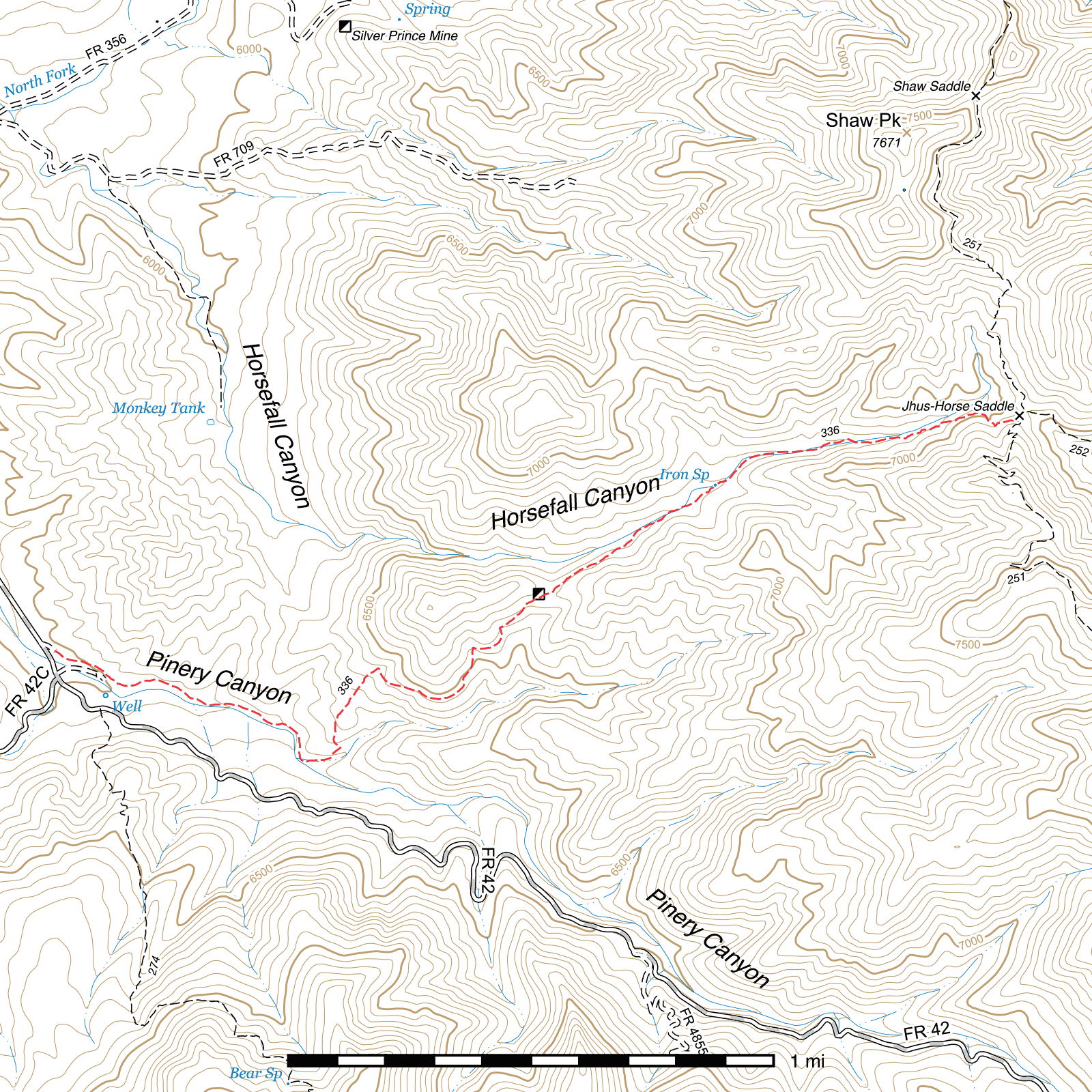
Pinery Horsefall Trail #336
Current Conditions
As of April 2019, the entire Pinery Horsefall Trail was cleared of deadfall, brushed and portions of the tread were improved. The lower section out of Pinery Canyon still had some very grassy and rocky sections compared to higher on the trail, but it was otherwise in great condition. The trail has not been surveyed since.
Length: 2.68 mi
Difficulty: moderate
Condition: moderate
Elevation range: 6000 ft – 7070 ft
Access
This trail is accessible from two locations.
The lower-elevation western terminus is located at the end of a 0.1 mile road off Pinery Canyon Road (FR 42) which also serves as access to a dispersed campsite. This road is located almost across FR 42 from Downing Pass Road (FR 42C).
The higher elevation eastern terminus is at Jhus Horse Saddle along the Shaw Peak Trail. The Jhus Horse Saddle Trail drops to the east into Jhus Canyon 130 feet to the north.
Trail Description
Starting in Pinery Canyon, the trail departs the end of a short road and almost immediately crosses a (usually dry) creekbed before turning right and heading east parallel to the creek. After half a mile sticking fairly close to the creek along several bends—the last one shifting the trail to head nearly south for a short stretch—you'll begin climbing to the east-northeast and leave the creek and its riparian area behind. After the first 300 feet of climbing the trail begins heading roughly north for a while, then, contouring widely around a large protruding ridge, gets in position for its overall northeastern route. 0.8 miles after exiting the riparian area and passing across a stretch of hot, dry, burned south-facing slope, you'll reach a saddle atop a ridge separating Pinery and Horsefall Canyons.
It's two thirds of a mile down to the bottom of Horsefall Canyon. There are no switchbacks, but it's a reasonably gradual descent. If coming from the other direction special care must be taken to find the point where the climb begins, as it can be easily missed and you'd end up in an entirely different location in the North Fork of Pinery Canyon. The next 400 feet through the canyon bottom is fairly badly burned and washed out and there is little sign of the trail. Continue up the canyon bottom and you should pick it up again during the 0.15 mile stretch to Iron Spring. The spring is located right alongside the trail and is easily visible with a concrete springbox. A sign for the spring is present on a tree. Except in dry periods, this spring should have water.
The next third of a mile runs along the south side of the creekbed, sometimes dropping into it briefly. It can be somewhat faint, but is usually followable. Downed logs are likely to be present in places as there was some fire damage through here, but many of the trees remain alive. The final 0.37 miles climb out of the canyon bottom along the southern slope of Horsefall Canyon to the eastern terminus with the Shaw Peak Trail at Jhus Horse Saddle. The Jhus Horse Saddle Trail into Jhus Canyon begins 130 feet to the left, with the Hilltop Mine several miles beyond. Onion Saddle is several miles to the right.
Map

Last updated July 14, 2025.