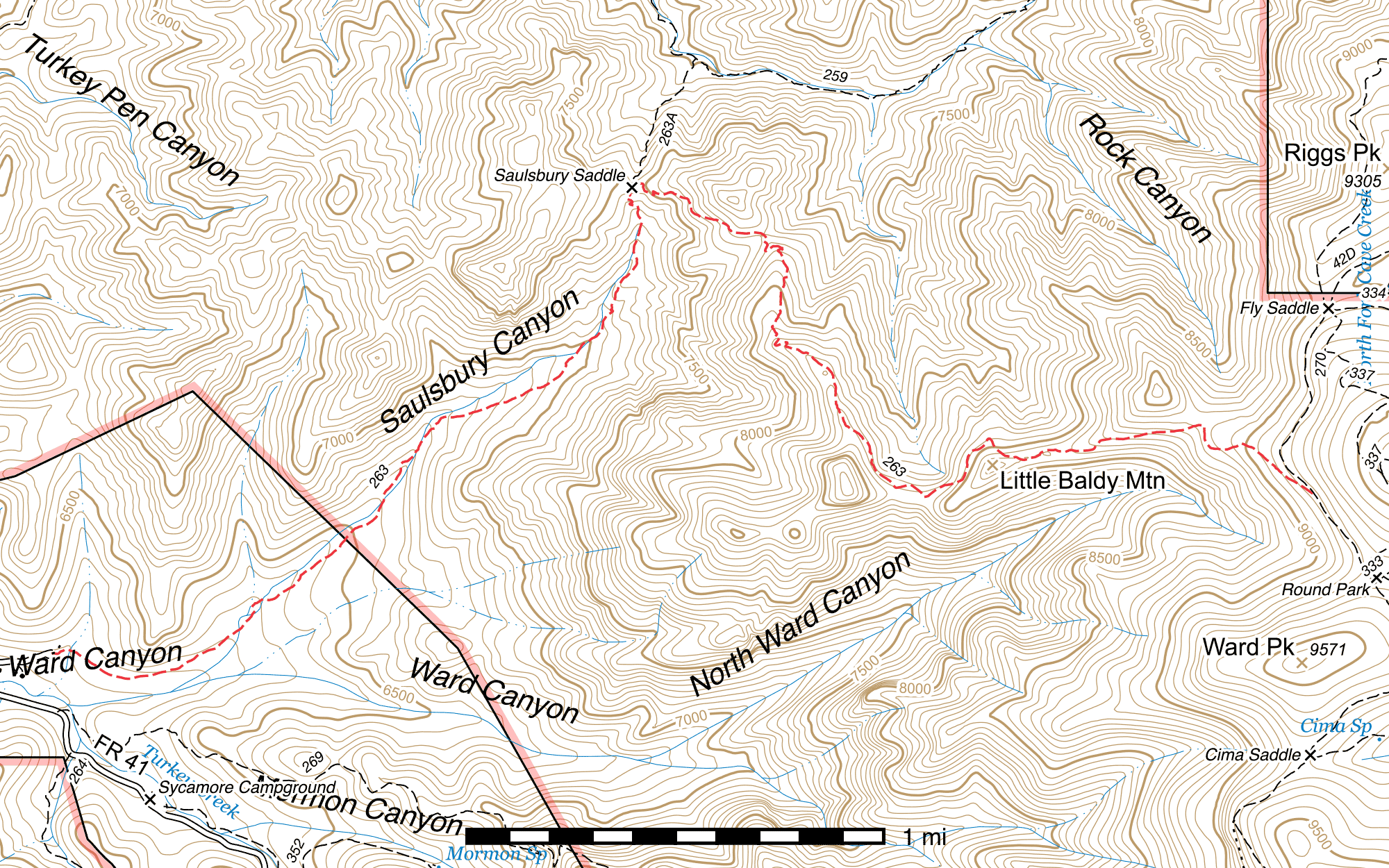
Saulsbury Trail #263
Important Note
The sign at Saulsbury Saddle appears to suggest the Saulsbury Saddle Trail continues from the north down the south side of Saulsbury Saddle all the way out to West Turkey Creek and the Saulsbury Trail begins at the saddle instead of West Turkey Creek. The older sign at the West Turkey Creek trailhead says otherwise, and this guide follows that interpretation.
Some sources, including at least one sign, spell this trail "Saulsberry" or "Salisbury" instead.
Current Conditions
This trail was completely restored in July 2025 by Wild Arizona's Youth Conservation Corps, but flooding that year caused a lot of damage in the lower half as well as portions of the middle section. Recent reports are of logs down, tread damage, and a lot of oak overgrowth. The top 2 miles were cleared of logs by the Chiricahua Wilderness Volunteer Trail Crew in 2024.
Length: 5.03 mi
Difficulty: difficult
Condition: bad
Elevation range: 6210 ft – 9165 ft
Access
The Saulsbury Trail is accessible from three locations.
The lower elevation western terminus (31.86558, -109.33872) is at the turnaround loop at the end of the Saulsbury Road (FR 632), 0.4 mile from the Turkey Creek Road (FR 41) (31.86564, -109.34503). This road is rough and has a stream crossing. High clearance vehicles are recommended. Note that the sign at the junction of Saulsbury and Turkey Creek Roads spells it "Saulsberry".
The Saulsbury Saddle Trail connects in from the north at Saulsbury Saddle, (31.88459, -109.31508) 2.31 miles above the lower terminus.
The higher elevation eastern terminus is at Saulsbury Junction along the Crest Trail, (31.87195, -109.28715) ¼ mile north of Round Park.
Trail Description
West Turkey Creek Trailhead to Saulsbury Saddle
- 2.31 mi
- 1215 ft ↑ 20 ft ↓
- 9.8% slope
Head east from the east edge of the turnaround loop at the end of the Saulsbury Road (FR 632). The trailhead is not signed right where it starts, but you will come to the sign approximately 200 feet northeast. (31.86575, -109.33822) Here, the trail swings down to the southeast and passes along a gradual slope burned by the 2011 Horseshoe 2 fire for a little under 0.2 mile before dropping down further into Saulsbury Canyon and paralleling the creek.
The next 0.3 miles of trail are in quite good condition, but as it begins to go back and forth across the creek, the trail quality reduces noticeably due to flooding damage. Several crossings are partially washed out, and rock flows across the trail can make it quite rocky in places, and occasionally obscure it entirely for a stretch.
This segment of the trail is only burned in a few areas, mostly towards the upper end, and is primarily under the cover of the trees at the bottom of Saulsbury Canyon. After another 1.38 miles, the trail comes to a small pair of switchbacks, then three more a third of a mile beyond that. From the last switchback, it's only 180 feet to Saulsbury Saddle. (31.88459, -109.31508)
Saulsbury Saddle to Crest Trail
- 2.72 mi
- 1710 ft ↑ 115 ft ↓
- 11.1% slope
The trail heads northeast out of Saulsbury Saddle, in the direction of an old, badly deteriorated sign 150 feet away. (31.88475, -109.31466) From here it swings to the right and begins to climb steadily in a generally southeastern direction for the next ⅖ mile, switchbacking only twice along the way. After a short drop to a shaded saddle—an excellent spot to rest—the climbing resumes immediately, this time to the south. The trail makes a switchback to the left and enters a grove of Gambel oak, then after two more switchbacks passes through a beautiful narrow corridor of the same.
⅕ mile after leaving the saddle the trail passes closely below a grassy but semi-open ridge with beautiful unburned pines and an excellent view out to the west. 0.15 mile south, it enters another saddle and after half a dozen switchbacks over 0.1 mile climbs along the ridgetop to the southeast. The trail soon crosses a high point and gradually descends for ⅙ mile. Here it reaches the bottom end of a 1.5 mile stretch that underwent maintenance in the spring of 2013 and the quality of the trail and ease of hiking it greatly improves all the way to the upper terminus.
Map

Last updated July 15, 2025.