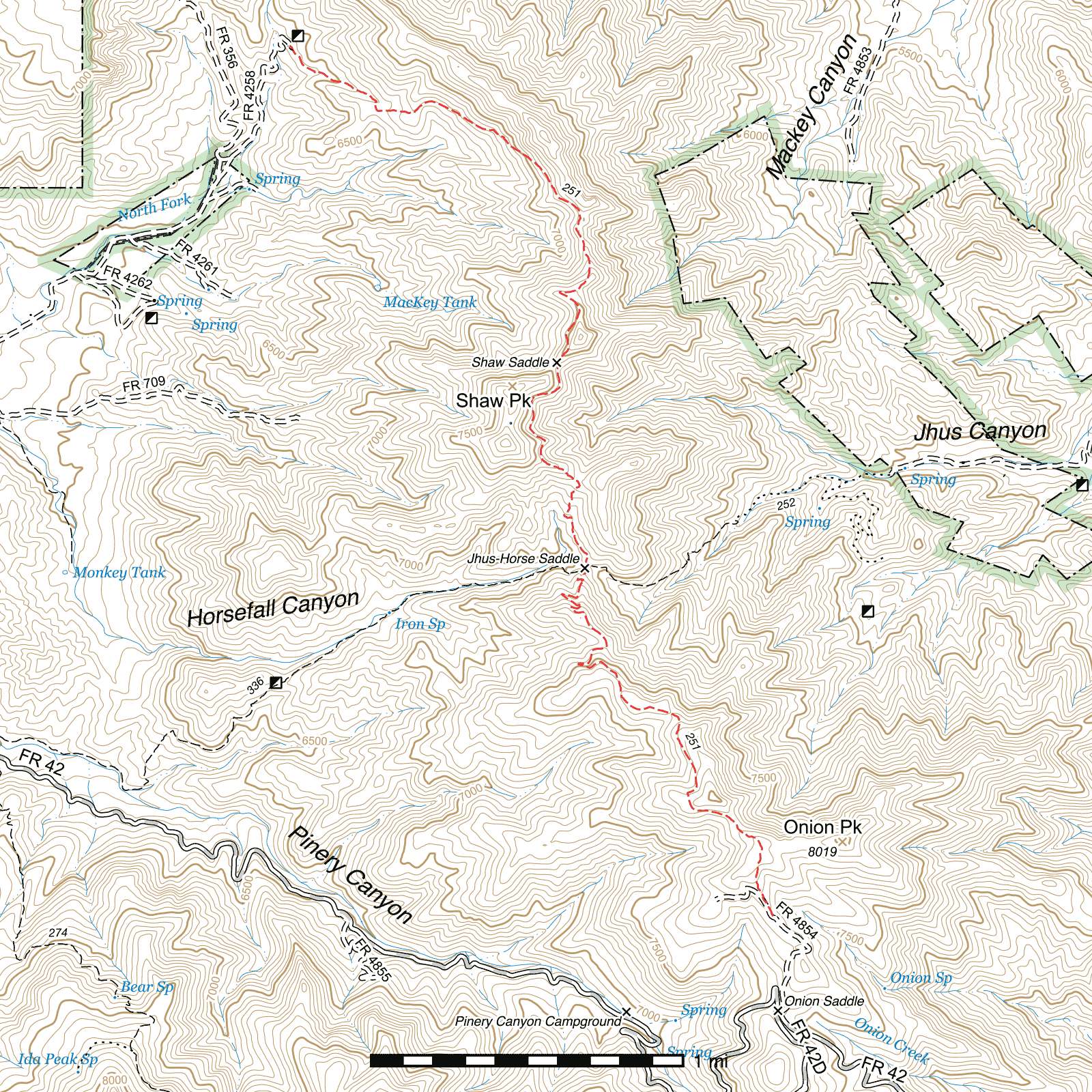
Shaw Peak Trail #251
Important Note
Older references, and some existing signs, consider the northern half of this trail, from Jhus Horse Saddle Trail to the Hilltop Mine, to be a separate trail named the Lime Trail. It is now considered to all be one single trail.
Current Conditions
A fencing crew did some trail maintenance in the summer of 2015 from the Onion Saddle Trailhead to Jhus Horse Saddle, but did not continue north of there, and conditions rapidly deteriorate beyond that point. Also beyond here, the new fence was built across the trail in places but the trail hasn't yet been rerouted to parallel it and line up with a new pedestrian gate installed. Just follow the fence until you come to the gate and pick up the trail again on the other side.
As of April 2019, approximately half a mile of the Shaw Peak Trail from Jhus Horse Saddle south to past the top of the switchbacks that climb out of the saddle was cleared of deadfall, brushed and had extensive tread reconstruction.
Length: 5.07 mi
Difficulty: difficult
Condition: bad
Elevation range: 6400 ft – 7970 ft
Access
The Shaw Peak Trail is accessible from three locations.
The southern terminus is 0.47 miles north of Onion Saddle via the Misfire Road (FR 4854). (31.93832, -109.26383) From Portal, head west out of town on Portal Road for a little over half a mile and angle to the southwest into Cave Creek Canyon, staying on the paved road. Road signs do not indicate this, but at the turn the road name changed to Cave Creek Road. After 0.77 miles, you will cross the National Forest boundary and the road becomes Forest Road 42. Continue up-canyon 3.3 miles, remaining on the paved road. After crossing a bridge, the pavement ends. Nearly two thirds of a mile further, you will pass the Southwestern Research Station on the left. Remain on Forest Road 42, which from this point on is commonly referred to as the Trans-Mountain Road. It is 7.19 winding miles to Onion Saddle, the mountain pass. The Misfire Road begins on the right hand side of the road just before the main three-way junction. (31.93317, -109.26356) This is a rough, narrow road and it may be advisable to park to the side of the road here and walk to the trailhead. The sign at the trailhead has burned, and only two wooden posts remain on the right side of the road, making it difficult to find where the trail begins. The first 400 feet of the trail parallel the road on the other side of a fence, so if you see that beside you or if you begin descending steeply along the road, you will know you have gone too far.
Jhus Horse Saddle, mid-way along the Shaw Peak Trail, has two junctions 100 feet apart, the Pinery Horsefall Trail (31.95720, -109.27426) coming out of Pinery Canyon from the west and the Jhus Horse Saddle Trail (31.95748, -109.27403) out of Jhus Canyon from the east. The former junction is signed (though the signs have burned somewhat) while the latter is unsigned.
The northern terminus lies at the end of Forest Road 4258, at the southern end of the Kasper Tunnel, one of many entrances to the abandoned Hilltop Mine. From Pinery Canyon Road (FR 42), (31.96940, -109.32084) take the North Fork Road (FR 356) approximately 2.1 miles to a fork. (31.97971, -109.29404) Take the right fork, Kasper Tunnel Road (FR 4258), and follow it to its end. The Shaw Peak Trail begins at the southeastern edge of the clearing in front of the Kasper Tunnel. (31.98565, -109.29013)
Trail Description
Onion Saddle Trailhead to Jhus Horse Saddle
- 2.1 mi
- 335 ft ↑ 1030 ft ↓
- 6.3% slope
From the trailhead along the Misfire Road, the trail parallels the road on the other side of a fence for 400 feet before angling away and climbing toward a saddle. The trailhead and south slope, along with the greater Onion Saddle area, were badly burned in the 2011 Horseshoe 2 fire, as were many of the south slopes along this trail. Fire damage is very patchy and it is common to pass through beautifully forested north slopes still.
The saddle is reached after nearly two tenths of a mile, and a small clearing here seems to get occasional use as a campsite. From the north edge of the clearing, the trail descends through woods. This pattern of steep ascent through charred terrain followed by steep descent through forest is very common along this trail. You will exit the woods shortly and curve to the west across another burned patch with a view of a side canyon off Pinery Canyon below and the main canyon in the distance. A short distance north and the trail curves right and then left again through another lush stand of pines.
After a quarter mile heading north, the trail angles up to near the ridge top and follows it around to the west, where it follows the same heavy burn pattern. Three tenths of a mile later, it crosses the ridge and passes through a flat area for a short distance before beginning a steep descent. Jhus Canyon should be visible to the north-northeast as you drop towards and pass through a series of switchbacks over the next three tenths of a mile. After a flatter stretch of trail along a ridgetop, with additional views of Jhus—you may be able to pick out the Jhus Horse Saddle Trail climbing its way up the slope.
An additional series of switchbacks over the next 0.35 miles drops the trail to Jhus Horse Saddle, between Jhus and Horsefall Canyons. It can occasionally be difficult to tell which is the correct route during this descent, as smugglers using this route frequently take steep shortcuts between the switchbacks. The trail itself generally follows the more gradual and less-traveled route.
Jhus Horse Saddle has two junctions, 100 feet apart. The first is located at the bottom of the switchbacks, where two partially burned signs stand. The Pinery Horsefall Trail descends to the west from here. (31.95720, -109.27426) 100 feet northeast, at an unmarked junction, the Jhus Horse Saddle Trail does the same to the east. (31.95748, -109.27403) The Shaw Peak Trail continues north.
Jhus Horse Saddle to Shaw Saddle
- 1 mi
- 510 ft ↑ 130 ft ↓
- 7.2% slope
Heading out of Jhus Horse Saddle, the trail sticks to the side of a western slope for two tenths of a mile before turning left at a steep side drainage crossing and climbing steeply up the spine of a ridge for 0.16 miles before turning northwest and continuing to climb. After 420 feet, a small old mining prospect site lies 30 feet to the northeast across a barbed wire fence. (31.96277, -109.27520) Another prospect is immediately to the left of the trail approximately 300 feet beyond. Shortly after, the trail comes to a high point at the base of a barren peak. (31.96313, -109.27627) USGS maps identify the next peak to the north as being Shaw Peak, while some individuals believe this is Shaw Peak. Whatever it may be, this is the best point along the trail to start climbing it. Very old maps from the early 1900s show the original trail out of Jhus Canyon as connecting in at this spot, but no evidence of it has been found yet.
The trail enters a wooded section and narrows significantly as it contours around the twin peaks here. After nearly three tenths of a mile, it curves to the right to contour around a ridge descending from Shaw Peak, then back to the left again to arrive at Shaw Saddle 0.18 miles later. (31.96861, -109.27569) A faint trail appears to leave this saddle to the southwest but it has not been surveyed at this time. Remnants of a sign are also present here, but it is unclear what it once said.
Shaw Saddle to Hilltop Mine
- 1.97 mi
- 140 ft ↑ 1105 ft ↓
- 9.3% slope
Heading out of Shaw Saddle, the Shaw Peak Trail continues to the northeast along the western slope of a third peak for ⅕ mile before swinging to the northwest atop a ridge. 0.1 mile later along the ridge, the trail makes a sharp switchback to the east, marked by a sign. (31.97246, -109.27554) There is a faint trace of a trail heading west from here as well, in the direction of MacKey tank.
The real trail is in a nicely forested stretch for the next 0.1 mile, the last you'll encounter on this trail. After exiting it, now beginning to swing northwards, you will be in one of the most barren parts of the trail, the fire having burned it so hotly that little life remains. After a little under ⅕ mile you will come to a bright white rock outcrop (31.97543, -109.27434) which also provides a great opportunity to look down into MacKey Canyon over the ridge to the east.
The trail drops below and to the west of the ridge here and after just over 0.1 mile follows its curve to the northwest, now heading downhill. About ½ beyond (31.98202, -109.28085) you will be above the visible tailings of a mine adit below and to the southwest. From here it is only another 0.1 mile until the trail contours to the left around the end of a side canyon and climbs several hundred feet to pass over a saddle. (31.98230, -109.28345)
From here it's down the ridge to the west for a little over 0.1 mile to another saddle, (31.98235, -109.28546) then northwest through a switchback and into a small drainage for nearly 0.3 mile. After exiting the drainage and crossing it for the last time, it's just 0.13 mile northwest to the northern terminus at the end of the Kasper Tunnel Road (FR 4258). (31.98566, -109.29011) The entrance to the Kasper Tunnel itself is just over 100 feet due north.
Map
Last updated July 15, 2025.