Snowshed Basin Trail
Important Note
Not to be confused with the Snowshed Trail, which this trail is a connector to from the Herb Martyr Trail.
This is a trail with official USFS signage but does not have a trail number and does not appear on most maps. The inclusion of "Basin" in the trail may lead to some confusion, as it does not connect directly to the Basin Trail but rather to the Herb Martyr Trail, which was once part of the multi-segmented Basin Trail. The Basin Trail now only exists between Herb Martyr and a small trailhead/dispersed campsite along Forest Road 42.
Current Conditions
New fencing was installed along the southern portion of this trail and in some cases was installed closer to the trail, making walking here somewhat more precarious due to the proximity of barbed wire.
Length: 1.98 mi
Difficulty: moderate
Condition: moderate
Elevation range: 5525 ft – 5900 ft
Access
The Snowshed Basin Trail is accessible from four locations.
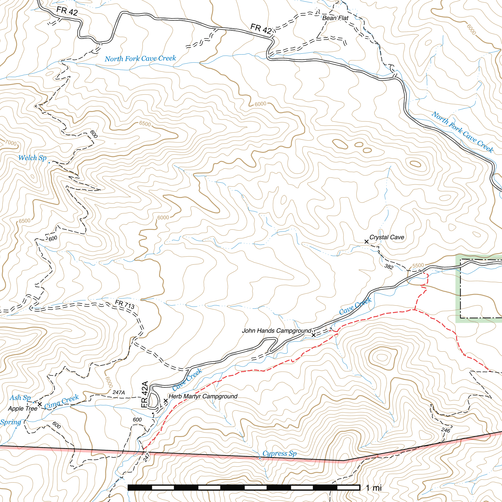
The lower-elevation eastern terminus is one mile above the northern terminus of the Snowshed Trail along Cave Creek Road (FR 42). At this junction, the Snowshed Trail heads west and the Snowshed Basin Trail northwest. There are signs at this junction, but they are in poor condition and rapidly deteriorating. (31.87565, -109.20998)
A quarter mile spur trail connects in from the Crystal Cave Parking Lot (31.88285, -109.21498) along the Herb Martyr Road (FR 42A). This small parking area lies just above a (usually dry) creek crossing which serves as the trailhead for the Crystal Cave Trail. The only sign naming the Snowshed Basin Trail as such lies at the trailhead of this spur, and the spur's junction with the the trail proper is also marked with signs.
A short spur trail connects in from the John Hands Campground along the Herb Martyr Road (FR 42A). (31.87869, -109.22193) To reach it, locate the dam (silted in) just below the campground along Cave Creek and head southeast. There is no sign on the campground end, but there is a sign at the junction with the Snowshed Basin Trail.
The higher-elevation upper terminus (31.86994, -109.23549) is at the wilderness boundary three tenths of a mile from the northern terminus of the Herb Martyr Trail at the upper Herb Martyr Parking Area at the end of the Herb Martyr Road (FR 42A).
History
This trail originated as a combination of a fenceline trail (along its southern portions) and a fireline (where it leaves the fenceline and connects to the Snowshed Trail. It was later developed into a hiking trail, with switchbacks in several locations and water control features.
Trail Description
Snowshed Trail to Crystal Cave Parking Lot Spur Trail
- 0.49 mi
- 25 ft ↑ 80 ft ↓
- 2.1% slope
In a small clearing marked with a dilapidated sign, (31.87565, -109.20998) just over 1 mile from the northern terminus of the Snowshed Trail, this trail angles off to the northwest while the Snowshed Trail continues in two directions to the east and west. The terrain is largely flat, with scrub oak providing moderate cover. This stretch of the trail can be quite hot in the summer. The Crystal Cave Parking Lot Spur Trail is marked with a sign and a pedestrian gate. (31.88018, -109.21562) Continue to the left to stay on the Snowshed Basin Trail or take the right fork for a quarter mile to reach the Crystal Cave Parking Lot along the Herb Martyr Road (FR 42A).
Crystal Cave Parking Lot Spur Trail to John Hands Campground
- 0.36 mi
- 60 ft ↑ 15 ft ↓
- 2.4% slope
Heading west-southwest through scrub oak, the trail crosses the bench above Cave Creek until it begins to parallel it after approximately two tenths of a mile. Over the next 700 feet, angles to the southwest and drops into a side drainage where a 200 foot spur trail (31.87858, -109.22125) leaves to the northwest for John Hands Campground and its accompanying (silted in) dam built between two boulders. A picturesque cascade of water can usually be seen here.
John Hands Campground to Herb Martyr Trail
- 1.13 mi
- 350 ft ↑ 30 ft ↓
- 5.4% slope
85 feet after passing the John Hands Campground spur trail, the trail makes a sharp bend to the right and climbs out of the drainage it had been briefly traveling along. 300 feet later, a memorial to Ramon P. "Monchi" Gonzales might be possible to still find on the right side of the trail, across the fence. Gonzales was the Arizona State Marble Champion.
The remaining mile gradually ascends, with occasional drainage crossings—one of which has a stone staircase installed to ease the climb out of the creek bottom. Paralleling Cave Creek the entire way, the trail stays above it and the creek is generally out of sight behind tree cover. As it approaches its upper terminus at the Herb Martyr Trail, the trail bends to the southwest. (31.86994, -109.23549) The signs at the junction have rotted, but you can turn left to ascend several miles and 2,000 feet in elevation to the Snowshed Trail just below Pine Park, or turn right towards the Basin Trail junction and the Herb Martyr Campground and parking area a short distance beyond.
Map
Last updated July 17, 2025.