Basin Trail #600
Important Note
Because this trail goes up and over a ridge, its average slope is misleading. Refer to the elevation gain/loss and segment-level slope for a more accurate indication of its steepness.
Some signs for this trail still show the old trail number (#247, the number now used by the Herb Martyr Trail), but it has been updated to #600 and will be shown as such on most modern maps.
Many maps incorrectly show this trail directly crossing the Greenhouse Road (FR 713). In fact, you must walk 0.69 mile on the Greenhouse Road to connect the two singletrack portions of this trail.
Some older maps incorrectly show the southern, Ash Spring portion of the Basin Trail as being its own trail with the number #247A, when that number is in fact the separate Ash Spring Trail. Newer maps have corrected this.
Current Conditions
As of March 2019, this trail was free of deadfall aside from one oak tree down within the first mile from the northern terminus along FR 42. The tread is in poor/narrow condition in several locations near Welch Seep. Mild catclaw overgrowth can be found in places, but isn't bad.
As of September 2019, the southern trailhead sign has been moved to the correct location at the lower Herb Martyr parking lot, near the restrooms.
Length: 5.25 mi
Difficulty: easy
Condition: good
Elevation range: 5815 ft – 6665 ft
Access
The Basin Trail is accessible from five locations.
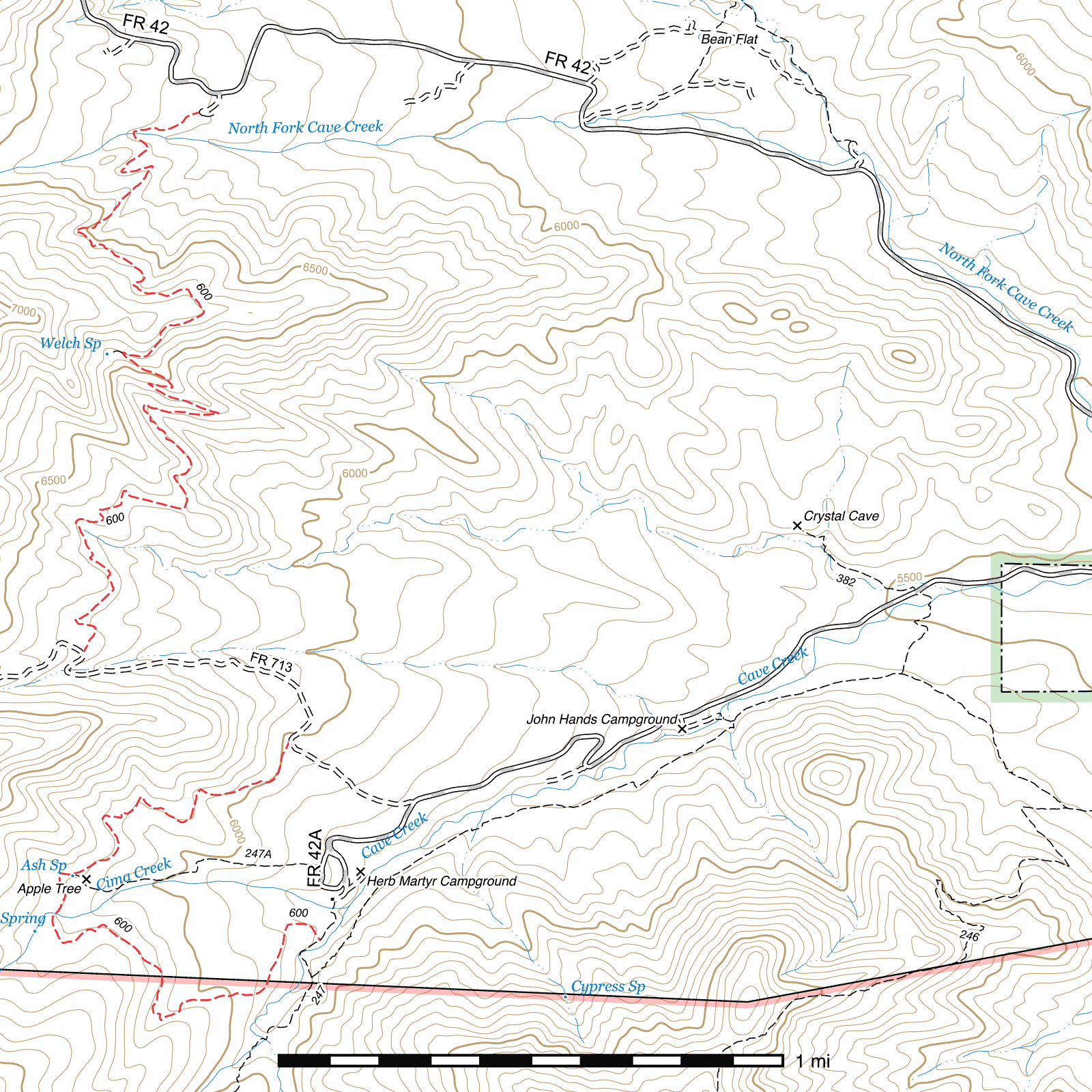
The northern terminus is located just off the Trans-Mountain Road (FR 42). A sign for the trail marks the entrance to a dispersed campsite. A small turnaround loop lies at the end of the road and the trails leaves from the southwestern corner. (31.89916, -109.23920)
The upper junction with the Greenhouse Road (FR 713) is 1 mile after that road leaves the Herb Martyr Road (FR 42A). A sign marks the start of the trail. (31.88082, -109.24324) The Greenhouse Road is rough and only 4WD vehicles are recommended, and the crossing with Greenhouse Creek several hundred feet before the trail junction is impassible by vehicle as of October 2015. You can park at the start of the road or a short distance beyond at the Herb Martyr upper parking area and walk up the Greenhouse Road, or park at one of several places along the road.
The lower junction with the Greenhouse Road (FR 713) is 0.3 mile after that road leaves the Herb Martyr Road (FR 42A). A sign marks this junction as well. (31.87789, -109.23619)
The short Ash Spring Trail connects from the end of the Herb Martyr Road right to Ash Spring itself, only a dozen feet north of the springbox. There is a trail sign in the general area of this junction, though as of October 2015 it is leaning over and another sign that helped clarify the junction has gone missing. (31.87341, -109.24360)
The southern terminus of the Basin Trail is at a junction with the Herb Martyr Trail a tenth of a mile south of the lower Herb Martyr Parking Lot. The junction is marked with two signs. (31.87120, -109.23522) The trailhead for the Herb Martyr Trail is also marked with an old Basin Trail sign at the southwest corner of the lower parking lot, near the restrooms.
History
Ash Spring was once the site of a homestead, built in the 1940s by Frank Pack, a local miner.1 He was later evicted by the Forest Service2 and the house burned down, but a chicken coop remains at the site.
Trail Description
FR 42 to Welch Seep
- 1.19 mi
- 430 ft ↑ 110 ft ↓
- 5.1% slope
From the southwestern-most point in the turnaround at the end of the dispersed campsite off Forest Road 42 that also serves as trailhead, the Basin Trail begins (31.89916, -109.23920) as a segment of two-track for 450 feet before narrowing to a single track trail the remainder of its length. 350 feet after the two-track ends, the trail crosses the north fork of Cave Creek and angles sharply to the left. (31.89844, -109.24151) Just before this crossing, a faint path may be visible continuing up along the creek. This disappears fairly quickly, but if the creek is followed for approximately 2 miles, you will reach North Fork Falls, a 50+ foot waterfall best viewed during spring snowmelt for peak water flow. (31.89032, -109.26241) Note that it can be quite a rugged off-trail hike to get to the waterfall, especially after flooding has rearranged the area significantly and brought a lot of debris into the canyon.
Continuing from the creek, the Basin Trail begins to climb the north face of a ridge over the next 0.8 miles, with occasional switchbacks. Upon cresting the ridge, (31.89243, -109.23913) you are greeted with a spectacular view of Silver Peak, the Cave Creek Basin and the red cliffs of Cave Creek Canyon and Reed Mountain behind. The rock outcrops around Winn Falls are visible, but the waterfall itself is obscured from this angle.
It's mostly downhill from here. 0.2 miles ahead lies the 100 foot spur trail (marked by a sign) (31.89101, -109.24189) to Welch Seep, a small undeveloped spring. The spring itself is fenced in, with grasses obscuring visibility, but you can usually find a pool of water here. (31.89097, -109.24241)
Welch Seep to Greenhouse Road
- 1.52 mi
- 130 ft ↑ 375 ft ↓
- 3.1% slope
Numerous switchbacks occur over the remaining 1.52 miles, the trail contouring around the terrain as it drops to its southern terminus with the Greenhouse Road (FR 713). There are a couple narrow spots in the trail, but they are easily crossed. A nearly continuous supply of excellent views can be enjoyed along this segment, with the Cave Creek Basin clearly visible below, Snowshed Ridge across the Basin, and parts of the Crest up above to the southwest. Once reaching the road, a trail sign indicates the various options from this location. (31.88082, -109.24324) The Greenhouse Trail begins 0.43 miles up the road to the right, while the Basin Trail follows the road to the left.
Greenhouse Road (FR 713)
- 0.69 mi
- 320 ft ↓
- 8.8% slope
This section of the Basin Trail follows Forest Road 713 and is quite straightforward to follow, but a bit rocky to walk on. From the signed junction, follow the road southwest for 250 feet until it crosses Greenhouse Creek (31.88036, -109.24374), then heads roughly east for the next 0.44 mile before gradually curving in a southern fashion, then southwest after 1,000 feet to the next signed junction where the Basin Trail again leaves the road, also heading southwest. (31.87789, -109.23619)
Greenhouse Road to Ash Spring
- 0.77 mi
- 165 ft ↑ 10 ft ↓
- 3.8% slope
The single-track trail resumes at a signed junction on the west side of the Greenhouse Road (FR 713). The trail contours with the terrain and gradually descends to Ash Spring, passing through scrub oak and juniper. The tree cover changes abruptly immediately around the spring and its adjacent meadow, the site of a former homestead. A partially collapsed wooden chicken coop between two trees and other debris can still be seen nearby. The spring lies just off the trail to the south. The Ash Spring Trail bears left immediately before the spring and provides a shorter, alternate route back to the Herb Martyr Parking Area at about half a mile. The Basin Trail continues to the right, taking twice the distance but a more interesting route to return to the same area.
Ash Spring to Herb Martyr Trail
- 1.08 mi
- 10 ft ↑ 300 ft ↓
- 5.1% slope
From the spring, the trail briefly enters a clearing and crosses a stream before bearing left and entering a pine forest. 300 feet later, a pedestrian gate must be passed through. The trail continues through the woods a short distance before coming to a fern-filled meadow and, immediately after, crosses Cima Creek. After climbing and contouring a short distance, it exits the tall trees and reenters scrub, descending to a wash and back up another small ridge over 0.8 miles before coming to another pedestrian gate. From there it's only 400 feet to the junction with the Herb Martyr Trail. Turning left will take you back to the Herb Martyr Campground and Parking Area and turning right to a crossing with the central fork of Cave Creek, a junction with the Snowshed Basin Trail, or the Snowshed Trail high above.
Map
Footnotes
- Cachor Taylor, Hiking Trails and Wilderness Routes of the Chiricahua Mountains of Arizona, 1977, p. 118
- Kimrod Murphy, The Devil Played Hell in Paradise, First Edition, 2010, p. 83
Last updated July 25, 2025.