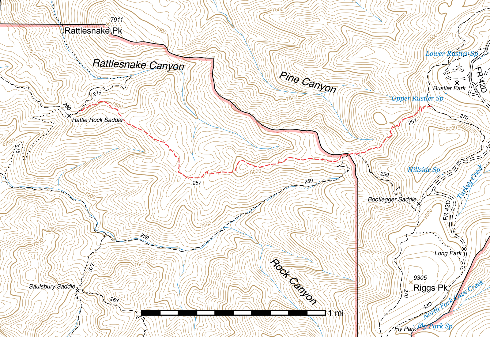
Bootlegger Trail #257
Important Note
Certain Forest Service maps provide an incorrect interpretation of this trail's route that may differ from this guide. Additional confusion may arise from the fact that the Bootlegger Trail does not connect to Bootlegger Saddle.
Also note that portions of what is now the Crest Trail were once considered part of the Bootlegger Trail and some older maps may show this. An old sign at Hillside Spring, just off the Crest Trail between Bootlegger Saddle and Rustler Park, indicates that trail segment as being part of the Bootlegger Trail.
Current Conditions
This area was heavily impacted by both the Rattlesnake and Horseshoe II fires, and in addition to potentially numerous trees down across the trail, there may be significant oak overgrowth in many places. The Chiricahua Wilderness Volunteer Trail Crew has been working on portions of this trail the last few years as of 2025, clearing deadfall, brushing the trail and improving tread.
Length: 2.63 mi
Difficulty: moderate
Condition: moderate
Elevation range: 7395 ft – 8835 ft
Access
The Bootlegger Trail is accessible from three locations.
The eastern terminus is a junction 0.37 mile south of the Rustler Park junction along the Crest Trail (31.90162, -109.28226) This junction is marked with a good quality sign and recent treadwork in the area as of July 2025 left it fairly well-defined.
The Rock Creek Trail connects with the Bootlegger Trail in two places 350 feet apart at Rock Saddle, both trails passing along the same route for the distance between. The eastern of the two junctions (31.89727, -109.28913) is marked by two signs while the western (31.89718, -109.29011) does have signs nearby but they have fallen over.
The western terminus is at a junction with the Rattlesnake, (31.90120, -109.31502) 350 feet east of Rattle Rock Saddle (31.90077, -109.31588). Both the junction and the saddle are signed. The Witch Ridge Trail is also accessible from Rattle Rock Saddle.
Trail Description
Crest Trail to Rock Saddle
- 0.73 mi
- 5 ft ↑ 545 ft ↓
- 14% slope
From the junction along the Crest Trail, (31.90162, -109.28226) the Bootlegger Trail climbs west to the ridge for 200 feet, where a broad view of the western Chiricahuas and the Sulphur Springs Valley beyond can be enjoyed. From the ridge, the the trail immediately begins to drop down to the southwest for 200 feet before switchbacking to the northwest for the same distance, then back to the southwest. For this segment of the trail, even if it briefly turns into a switchback or to contour around the terrain, the trail tends to maintain a southwesterly course.
After 400 additional feet down steep slopes, the trail crosses a more gradual ridge with little to no plant life beyond ferns. This area was burned in the 1994 Rattlesnake Fire and then again in the 2011 Horseshoe 2 fire, which cleared away all the dead tree logs and stumps that had previously littered the terrain. You may be able to see the "shadows" of the dead trees here, places where stumps lay before burning and where no plants have grown back. After two tenths of a mile and a few small switchbacks, the trail wraps around into a steep drainage. (31.89904, -109.28593)
It's another quarter mile to the first of two junctions at Rock Saddle, which is marked with signs. (31.89727, -109.28913) The Rock Creek Trail drops down to here from Bootlegger Saddle via the left fork, and both trails pass across the same route for the next 350 feet to the second junction, (31.89718, -109.29011) at which point the Rock Creek Trail drops away into Rock Canyon to the left. This latter junction is marked by signs but they have fallen over and are badly weathered. One sign indicates the clearing immediately north of this junction is Helispot 20.
Rock Saddle to Rattlesnake Trail
- 1.9 mi
- 110 ft ↑ 885 ft ↓
- 7.7% slope
Exiting the second junction, the Bootlegger Trail heads west along the upper fork and skirts along the top edge of pine forest for the next 150 feet before swinging southwest to contour around a hill and passing through the trees. The Rock Creek Trail can be seen descending a short distance below through here. After only 200 feet, it's back to the west again and just under a tenth of a mile before you're back out from under the canopy and on an initially semi-exposed and shortly after completely exposed ridge.
The next 0.4 mile stays roughly atop the ridge as it drops elevation to a saddle, then it swings around the north side of a hill before returning back to the ridge. ⅓ mile after the saddle, the trail comes to a pair of small switchbacks, (31.89537, -109.30301) then describes a U as it drops southwest, then west to a saddle, followed by climbing to to the northwest and north to another saddle. (31.89805, -109.30677) This area burned hot and there has been erosion damage, causing the trail to lose definition here. It crosses the saddle roughly to the northwest, and you should be able to pick it up on the other side.
It's only 0.3 mile to the next saddle, (31.90058, -109.31094) which some maps mislabel as Rattle Rock Saddle, and from there the trail re-enters unburned pine forest and drops another 0.3 mile to the Rattlesnake Trail junction. (31.90120, -109.31502) The actual location of Rattle Rock Saddle, the Witch Ridge Trail junction, and a continuation of the Rattlesnake Trail down into Rock Canyon, lie 350 feet beyond to the left. Rattlesnake Canyon and the northern terminus of the Rattlesnake Trail in Pine Canyon is to the right.
Map

Last updated December 19, 2025.