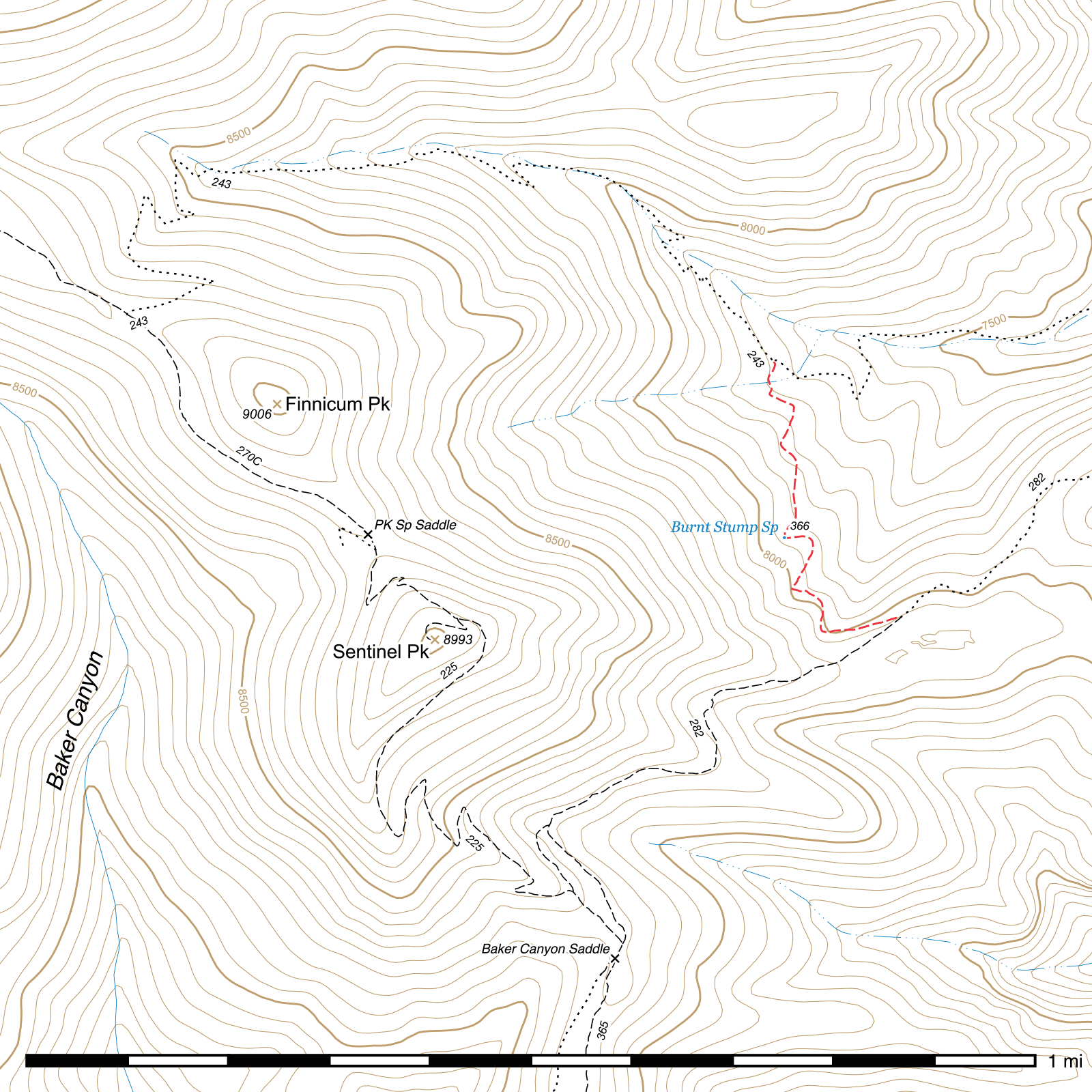
Burnt Stump Trail #366
Current Conditions
The entire length of this trail was restored in 2013 by the Chiricahua Wilderness Volunteer Trail Crew for the first time in several decades, but continuing deadfall and oak overgrowth combined with the poor quality of the upper South Fork Trail between 2014 and 2022 led to the decline of conditions again.
In fall of 2024, the Chiricahua Wilderness Volunteer Trail Crew again cleared logs off this trail and brushed it, though there are likely still some narrow tread spots in places.
Length: 0.48 mi
Difficulty: moderate
Condition: moderate
Elevation range: 7680 ft – 8010 ft
Access
The Burnt Stump Trail is accessible from two locations.
The lower elevation northern terminus (31.81839, -109.23700) leaves the South Fork Trail shortly after it begins climbing out of the canyon bottom for the final time and ascends towards its southwestern terminus at the Crest Trail. At a switchback marked by a sign bolted to a tree, the Burnt Stump Trail heads left while the South Fork Trail continues through the switchback to the right.
The higher elevation southern terminus (31.81407, -109.23488) occurs along the upper end of the Horseshoe Ridge Trail, nearly 0.6 miles northeast of its own upper terminus. This junction is marked by two separate signs.
Trail Description
South Fork Trail to Burnt Stump Spring
- 0.24 mi
- 195 ft ↑
- 15.4% slope
The Burnt Stump Trail is a short connector between the South Fork Trail and the Horseshoe Ridge Trail, with access to a reliable water source midway along its length.
From the junction with the South Fork Trail, the Burnt Stump Trail heads south, contouring with the terrain. At a small drainage crossing, remnants of stone steps may help assist climbing the somewhat steep opposite side. There are several additional short steep sections along this trail, but they are not especially difficult to pass if you've managed to make it this far.
Burnt Stump Spring lies nearly exactly halfway along the trail's length at the end of one of these steep stretches, nestled into a small drainage. (31.81542, -109.23684) Its springbox is built out of metal and set into the ground, one corner open for water to flow out. It is located directly off the trail on the uphill side and is impossible to miss if you are on the trail itself unless it has been buried by debris from the slope above, which has happened in the past.
Burnt Stump Spring to Horseshoe Ridge Trail
- 0.24 mi
- 130 ft ↑
- 10.3% slope
From here the trail is fairly well defined, the final nearly quarter mile having been entirely rebuilt in 2013. After approximately 150 feet, the trail beginning to curve around to the right, you will pass over a pair of small seeps where, especially early in the morning, water may sometimes puddle on the trail. A little over 300 feet beyond, a once very problematic steep and narrow drainage crossing has been rebuilt and widened, and from there it's just a few more curves and a comparatively gradual climb to the end of the trail. The final 400 feet can often be quite brushy unless recently maintained.
Upon reaching the Horseshoe Ridge Trail, (31.81407, -109.23488) its junction marked by two signs, you can turn left to loop around to Horseshoe Saddle and the Burro Trail and drop back down into South Fork at Maple Camp, or turn right in the direction of Sentinel Peak, the Jones Ridge Trail, Baker Canyon Trail and Crest Trail, the last of which can be followed back to the upper terminus of the South Fork Trail for a different loop.
Map
Last updated July 13, 2025.