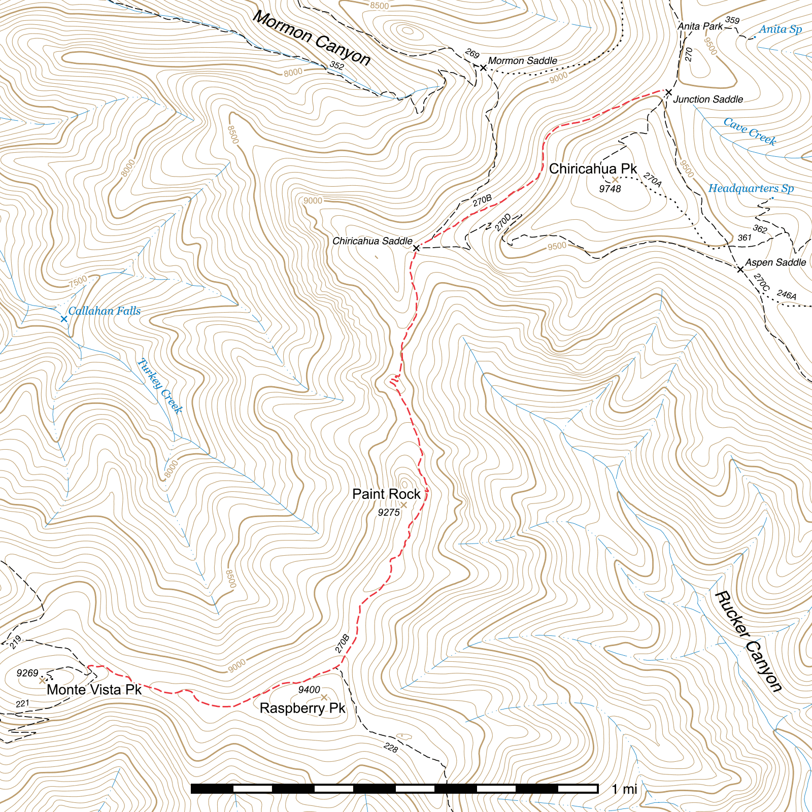
Crest Trail - Junction Saddle to Monte Vista Peak #270B
Important Note
The sign at Junction Saddle for this trail currently says 270 rather than 270B, but the sign at the Mormon Ridge Trail junction indicates it is 270B.
Current Trail Conditions
As of May 2018, this trail has been cleared in its entirety of aspen overgrowth and over 60 downed trees by several volunteer trail crews.
As of May 2019, the section between Junction Saddle and Chiricahua Saddle was cleared by a Sierra Club service trip but has not been scouted further south for the season.
Length: 2.9 mi
Difficulty: easy
Condition: good
Elevation range: 9000 ft – 9430 ft
Access
This leg of the Crest Trail is accessible from five locations.
The northern terminus is at Junction Saddle, where the northern and southeastern legs of the Crest Trail come together along with the Chiricahua Peak Trail that climbs to the summit. (31.84959, -109.28897)
The upper end of the Mormon Ridge Trail connects in at a signed junction 250 feet northeast of Chiricahua Saddle. (31.84346, -109.29888)
Directly at Chiricahua Saddle, the west end of the Crest Trail - Chiricahua Peak Bypass descends off the southwestern spine of Chiricahua Peak as it arrives from Aspen Saddle, at another signed junction. (31.84307, -109.29953)
Just north of Raspberry Peak, the Raspberry Ridge Trail connects to the southeast side of the trail. This junction is also signed. (31.82549, -109.30293)
The southern terminus is at a junction along the Turtle Mountain Trail, (31.82548, -109.31326) only 80 feet northwest of that trail's own upper terminus along the Monte Vista Trail on the east side of Monte Vista Peak. (31.82530, -109.31313) These junctions are all well-marked with signs, though the Turtle Mountain sign has broken into two pieces and can no longer be fully read.
Trail Description
Junction Saddle to Chiricahua Saddle
- 0.83 mi
- 300 ft ↓
- 6.9% slope
As it leaves Junction Saddle, (31.84959, -109.28897) the trail heads northwest very briefly before angling to the southwest and gradually dropping as it skirts around the west side of Chiricahua Peak. Before entering the unburned old growth forest as you continue towards Chiricahua Saddle, you can enjoy a great view down Mormon Ridge and Canyon below.
A little over ¾ mile after leaving Junction Saddle, you will reach a signed junction with the upper terminus of the Mormon Ridge Trail. (31.84346, -109.29888) Chiricahua Saddle lies 250 feet beyond, (31.84307, -109.29953) with another signed junction where the Chiricahua Peak Bypass heads east to Aspen Saddle.
Chiricahua Saddle to Raspberry Ridge Trail
- 1.38 mi
- 340 ft ↑ / 225 ft ↓
- 1.6% slope
Immediately after departing Chiricahua Saddle, the trail turns south and begins to descend. After a final tenth of a mile under the canopy of live conifer forest, you will exit into the comparatively barren and exposed environment that dominates much of the remainder of the length of this trail. On the bright side, the views from here on are among the best in the Chiricahuas. You're immediately greeted with a view down the length of Rucker Canyon, the rock cliffs on the south face of Chiricahua, and Aspen Saddle, Aspen Peak and the eastern leg of the Crest Trail running out towards Sentinel Peak in the distance.
You'll soon enter a stand of young aspen, growing back after the 2011 Horseshoe 2 fire and often encroaching on the trail if it hasn't been recently cut back. As this continues to grow, it will likely create a bit of a corridor that again blocks the view of Rucker Canyon in this area, but after another 800 feet the trail contours around and transitions onto the spine of the ridge itself, where everything opens up and you have views in both directions. A small, rocky protrusion will be visible ahead of you as you cross the lowest spot on this trail, and you'll soon reach it and first gradually climb towards and then ascend in earnest through a series of several short switchbacks before curving around the west side of the rocks and heading southeast to descend back onto the ridgetop. This area is one of several great snack or lunch spots, though better ones lie ahead.
After another thousand feet, traveling almost in exactly a straight line south-southeast, while approaching Paint Rock, you will come to one of those spots, a rock outcrop on the east side of the trail that provides one of the best views into Rucker Canyon. (31.83441, -109.29912) From here, the trail briefly crosses solid rock and can be somewhat hard to spot. There is often a cairn or two to help you along near here, but if you look to the south you'll no doubt pick it up quickly.
Here begins one of the most spectacular and interesting parts of the entire trail, not counting the views along most of its length. As it passes beneath and along the red rhyolite of Paint Rock towering overhead, the trail clings to the edge of the cliff and in places appears to have been carved or blasted out of the rock. Aspen and other plants can sometimes grow into the trail through here as well, but it's hard to miss. After a little over a tenth of a mile, you'll come to a set of steep switchbacks that take you up through the one narrow gap in the rock and shortly return you to the ridgetop. Here is perhaps the best lunch spot, where rocks that are part of the Paint Rock formation extend out into the canyon below and provide a high perch perfect to sit on. (31.83289, -109.29890)
The 0.6 mile to the next trail junction are fairly straightforward, running right on the top of the narrow ridge a majority of the time. Along here, you can even get a peek of Sentinel Peak and its distinctive scree fields at the terminus of the eastern leg of the Crest Trail. The Raspberry Ridge Trail is marked by a sign.(31.82551, -109.30292)
Raspberry Ridge Trail to Turtle Mountain Trail
- 0.69 mi
- 85 ft ↑ / 125 ft ↓
- 1.1% slope
Angling to the southwest across the north face of Raspberry Peak, the trail almost immediately enters an area of heavy destruction and rapidly degrades in condition. This area was hit hard by the Horseshoe 2 fire, though after 0.13 miles the trail passes through a tenth of a mile of surviving pine canopy. Expect a lot of downed trees and aspen growing up in the trail, however. The final 0.45 miles of the Crest Trail, angling to the northwest, alternate between small burned and unburned stretches. 30 feet from the end, the trail swings sharply to the left and climbs to meet the Turtle Mountain Trail at the Crest's southwestern terminus. (31.82548, -109.31326) The last stretch of the Monte Vista Trail to the Monte Vista Fire Lookout begins 80 feet to the left at the end of the Turtle Mountain Trail.
Map
Last updated May 17, 2019.