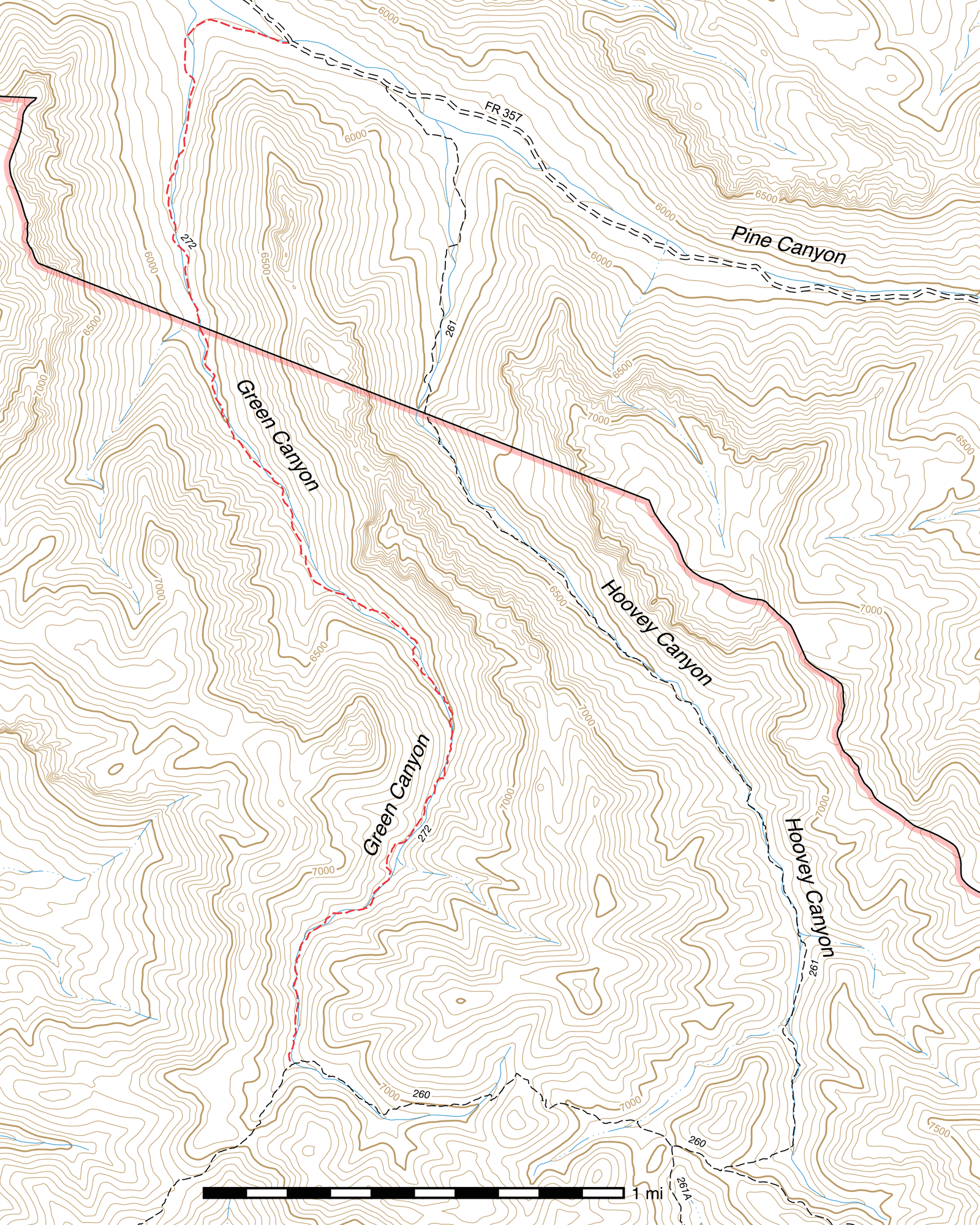
Green Canyon Trail #272
Current Conditions
As of May 2015, most of this trail is heavily overgrown with oak, ceanothus and manzanita. The trail is largely well-marked with large rock cairns, but they are sometimes partially obscured in the plant growth.
Length: 3.71 mi
Difficulty: difficult
Condition: terrible
Elevation range: 5720 ft – 6830 ft
Access
The Green Canyon Trail is accessible from two locations.
The lower-elevation northern terminus (31.95405, -109.35263) is along Pine Canyon Road (FR 357), 2.67 miles down-canyon from its junction with Downing Pass Road (FR 42C), accessible via Pinery Canyon Road (FR 42). The trail begins as an old logging road. This junction is marked with a sign saying "Green Canyon".
The higher elevation southern terminus is along the Witch Ridge Trail, (31.91264, -109.35260) 1.21 miles west of its junction with the Fitch Corral Trail and 1.76 miles northeast of its junction with the Fife Canyon Trail. This junction is unsigned but is marked by rock cairns.
Trail Description
From Pine Canyon Road (FR 357), the Green Canyon Trail heads northwest along an old logging road for ⅕ mile before swinging south into the mouth of Green Canyon itself. After approximately another ⅖ mile heading south, you will come to a Wilderness boundary sign. (31.94956, -109.35714) The old roadbed continues for about 0.28 mile beyond before becoming faint and turning into a rugged trail.
A large amount of the Green Canyon Trail is close to the creekbed, and while many parts are quite well defined, it can disappear at times due to a combination of overgrowth and flooding damage. It sticks very close to the canyon bottom for its entire length, however, so if it ever disappears you can just continue along the creek and you are almost guaranteed to pick it up again. It is quite well marked with rock cairns in the areas where it is prone to disappearing or where a creek crossing is not otherwise noticeable—many of the cairns utilize a red rock at the top to aid in visibility.
Green Canyon burned quite badly in places, and there are large stretches where all the pines that once filled it are dead. Not everything is a total loss, however, and in years of heavy rain other plant life can help bring give a temporary resemblance of the greenness the canyon was named after.
1.86 miles up-canyon from where the road grows faint, you will come to a fork in the canyon, with a small waterfall in the main fork on the right. (31.92364, -109.34681) For a couple hundred feet beyond here, the trail passes between the narrow canyon walls and crosses bedrock. Approximately 0.12 mile beyond, a small cave lies just 20 feet northeast of the trail (31.92187, -109.34795), large enough to provide shelter from a storm for several people.
After an additional ⅘ mile, passing through several bends in the canyon, you will reach the upper terminus of the Green Canyon Trail at its junction with the Witch Ridge Trail. (31.91264, -109.35260) This junction is marked with rock cairns but no signs. To the east, Fitch Corral Trail connects in 1.21 miles, the Hoovey Canyon Trail 0.15 mile beyond that, and the upper terminus of Witch Ridge at Rattle Rock Saddle 1.6 miles further. To the southwest, you can reach the Fife Canyon Trail in 1.76 miles.
Map

Last updated July 13, 2025.