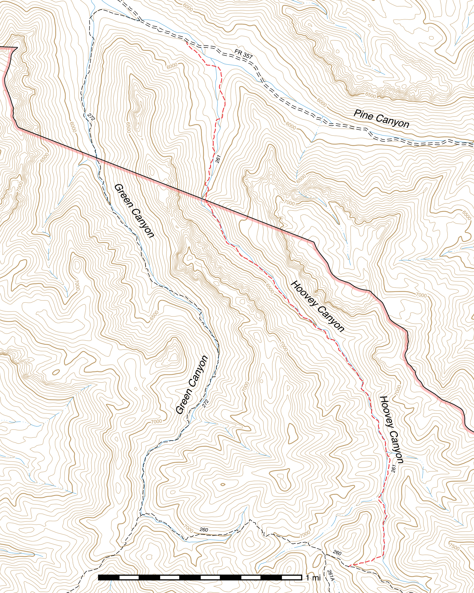
Hoovey Canyon Trail #261
Current Conditions
Post-fire recovery has led to a significant amount of overgrowth by oak, ceanothus, manzanita and other plants, especially in the heavily burned portions of this trail. Flood damage has blown out the trail in places or made creek crossings rockier than they were in the past. The lower 1.9 miles from Pine Canyon Road (FR 357) have been cleared as of late January 2016 by volunteer crews, and while conditions are likely passable above that point, expect moderate oak overgrowth and downed trees, as well as potential for washed out trail where it comes close to canyon bottom. The trail has not been surveyed since.
Length: 3.73 mi
Difficulty: moderate
Condition: bad
Elevation range: 5745 ft – 6980 ft
Access
The Hoovey Canyon Trail is accessible from two locations.
The lower-elevation northern terminus (31.95236, -109.34878) is along Pine Canyon Road (FR 357), 2.4 miles downcanyon from its junction with Downing Pass Road (FR 42C), accessible via Pinery Canyon Road (FR 42). The trail begins as an old logging road.
The higher elevation southern terminus is along the Witch Ridge Trail, (31.90836, -109.33520) 1.6 miles northwest of that trail's eastern terminus at Rattle Rock Saddle and 0.15 miles southeast of its junction with the Fitch Corral Trail. This terminus is marked by two signs.
Trail Description
From Pine Canyon Road (FR 357), the Hoovey Canyon Trail departs to the south, then almost immediately swings southeast. The first approximately ⅔ mile of this trail follows an old roadbed. The lower end of Hoovey Canyon was burned fairly badly by the 2011 Horseshoe II Fire, and many of the trees here are dead. Around the Wilderness boundary, the road narrows and turns into a proper trail, closely following the creek but sticking to its west bank. There are numerous thorny plants encroaching on the trail through here, and wearing shorts is not recommended.
⅓ mile after crossing the Wilderness boundary, the trail crosses the creek (31.94028, -109.34720) and climbs semi-steeply up the slope on the opposite side. It stays high for about ⅕ mile before dropping back down into the creekbed. Hoovey Canyon is a fairly narrow canyon, and the trail frequently disappears at its lower points. Sometimes it climbs high out of the canyon bottom and other times it sticks right next to it, crossing frequently. At times it may be easier to just walk up the creekbed, which has been cleared out by flooding and in most places is an easy walking surface with sand and gravel.
After another 0.8 mile, a decent-sized grotto lies immediately off the south side of the trail (31.92921, -109.33908).
1¼ miles of largely following the canyon bottom follows. Starting a little before here and lasting most of the rest of the trail, Hoovey Canyon was not burned especially badly and is quite beautiful, with a relatively dense pine and fir canopy in most places, and interesting rock formations visible on the cliffs above where it's possible to see through the trees. The fire seems to have mostly cleared out the underbrush, leaving the big trees intact.
Eventually, you will reach a fairly major fork in the canyon (31.91437, -109.33251), with West Hoovey Canyon connecting in from the southwest. The trail climbs out of the drainage here for a time, between the two forks, then takes the main fork to the southeast and then south for nearly ⅖ mile before leaving the drainage for the final time (31.90937, -109.33230) and climbing ⅕ mile to a saddle where it connects at a signed junction with the Witch Ridge Trail (31.90835, -109.33520).
Hoovey Saddle and the junction with the Fitch Corral Trail lies 0.15 mile northwest, and the upper terminus of the Witch Ridge Trail is 1.6 miles southeast along the Rattlesnake Trail.
Map

Last updated July 14, 2025.