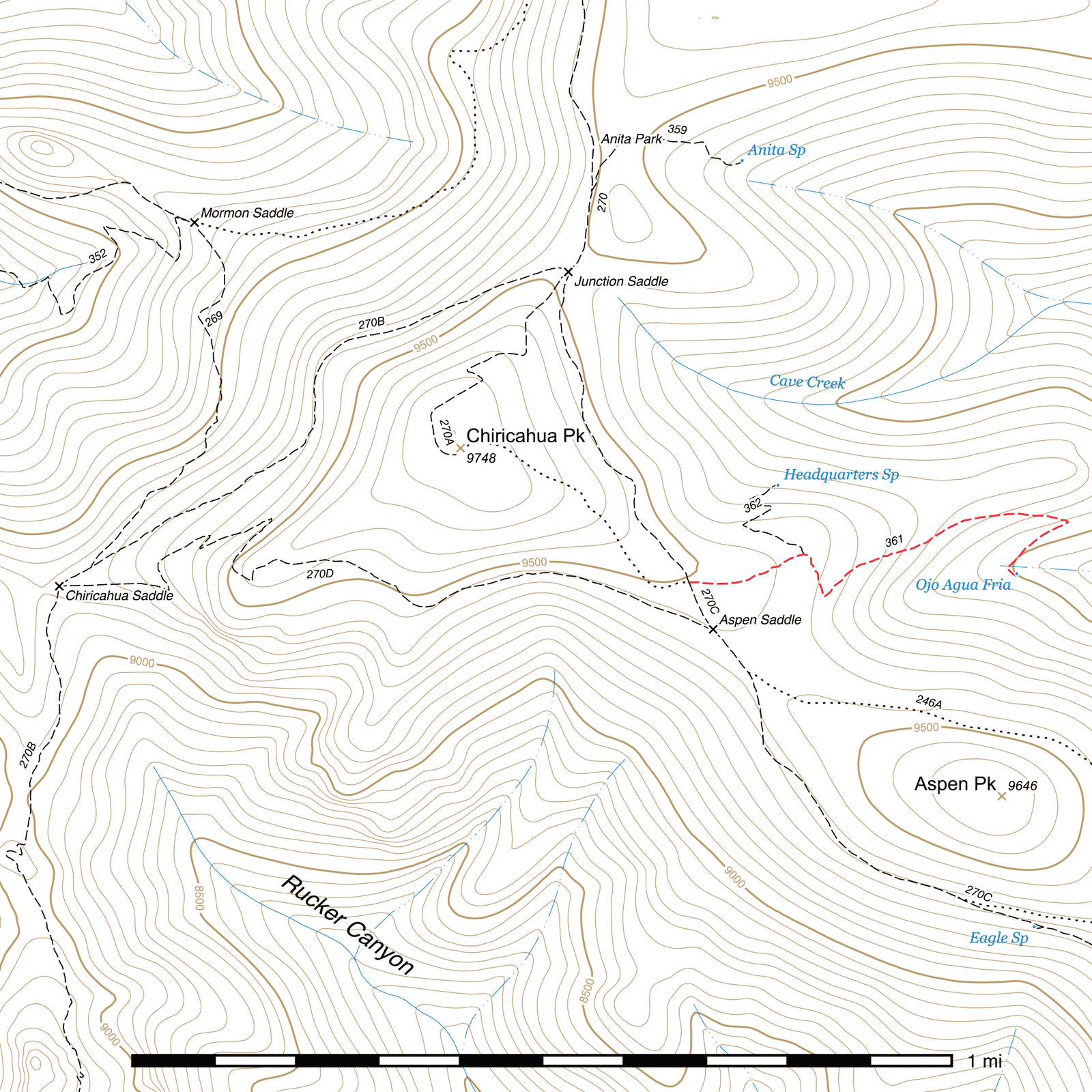
Ojo Agua Fria Trail #361
Current Conditions
As of early June 2018, the Ojo Agua Fria Trail has been cleared of all deadfall and had extensive tread reconstruction along its entire length by volunteers on a Sierra Club service trip. The trail has not been surveyed since below the Headquarters Spring junction and is likely in poor condition again.
Length: 0.68 mi
Difficulty: moderate
Condition: bad
Elevation range: 9000 ft – 9490 ft
Access
The Ojo Agua Fria trail is accessible via the southeastern fork of the Crest Trail at Aspen Saddle. From Junction Saddle, head southeast half a mile. From the Chiricahua Peak Bypass Trail, head northwest 400 feet. The junction is clearly marked by a sign. (31.84315, -109.28646)
Trail Description
Crest Trail to Headquarters Spring Trail
- 0.15 mi
- 85 ft ↓
- 10.7% slope
Heading east from the Crest, the trail gradually drops down past the north side of Aspen Saddle and begins to curve to the northwest. The trail is generally easy to follow. After 0.15 mile, the trail briefly flattens out on the top of a sort of ridge. The junction for the Headquarters Spring Trail, (31.84369, -109.28420) which forks off to the north here, is marked by a sign bolted to a tree, but it may be somewhat overgrown. It occurs just before the Ojo Agua Fria Trail makes a sharp rightward bend to the south-southeast.
Headquarters Spring Trail to Ojo Agua Fria
- 0.53 mi
- 430 ft ↓
- 15.4% slope
Leaving the old Headquarters camp, the trail begins descending immediately. The first switchback occurs about 350 feet beyond, (31.84286, -109.28368) after which the trail turns northeast for a long stretch. It is also around here that the trail emerges into a massive bowl of standing dead trees from the 2011 Horseshoe 2 fire. Expect downed trees across the trail for some time through here, especially during windy seasons. The trail has also become somewhat faint in places as a result of post-fire erosion, but should still be easy enough to follow. After a little over a quarter mile beyond the switchback, an old spur trail once took off and climbed northeast to a point on the ridge above where a helispot had been cleared. There is little trace of this trail at present.
Another 350 feet east and you'll reach the second switchback, (31.84440, -109.27859) and here the trail—now heading southwest—goes through some of its most eroded stretches. Remain heading this direction for 0.1 mile until the trail makes a hard left turn (31.84346, -109.27985) and drops the remaining distance to the Ojo Agua Fria tank. (31.84333, -109.27966) This is a silver metal aircraft style tank similar to those at Headquarters, Burnt Stump and Ida Peak Springs, and is currently lying between two lengths of a very large diameter dead tree which previously fell directly onto the tank and damaged it. Ojo Agua Fria was historically the highest flow spring in the Chiricahuas, with at least three gallons per minute output recorded at times. If the tank is empty (it probably is), it is likely that the hose from the spring source has become disconnected. You should be able to find the source about 50 to 75 feet to the southwest, flowing down into the drainage bottom as the headwaters of the main fork of Cave Creek.
Map
Last updated July 14, 2025.