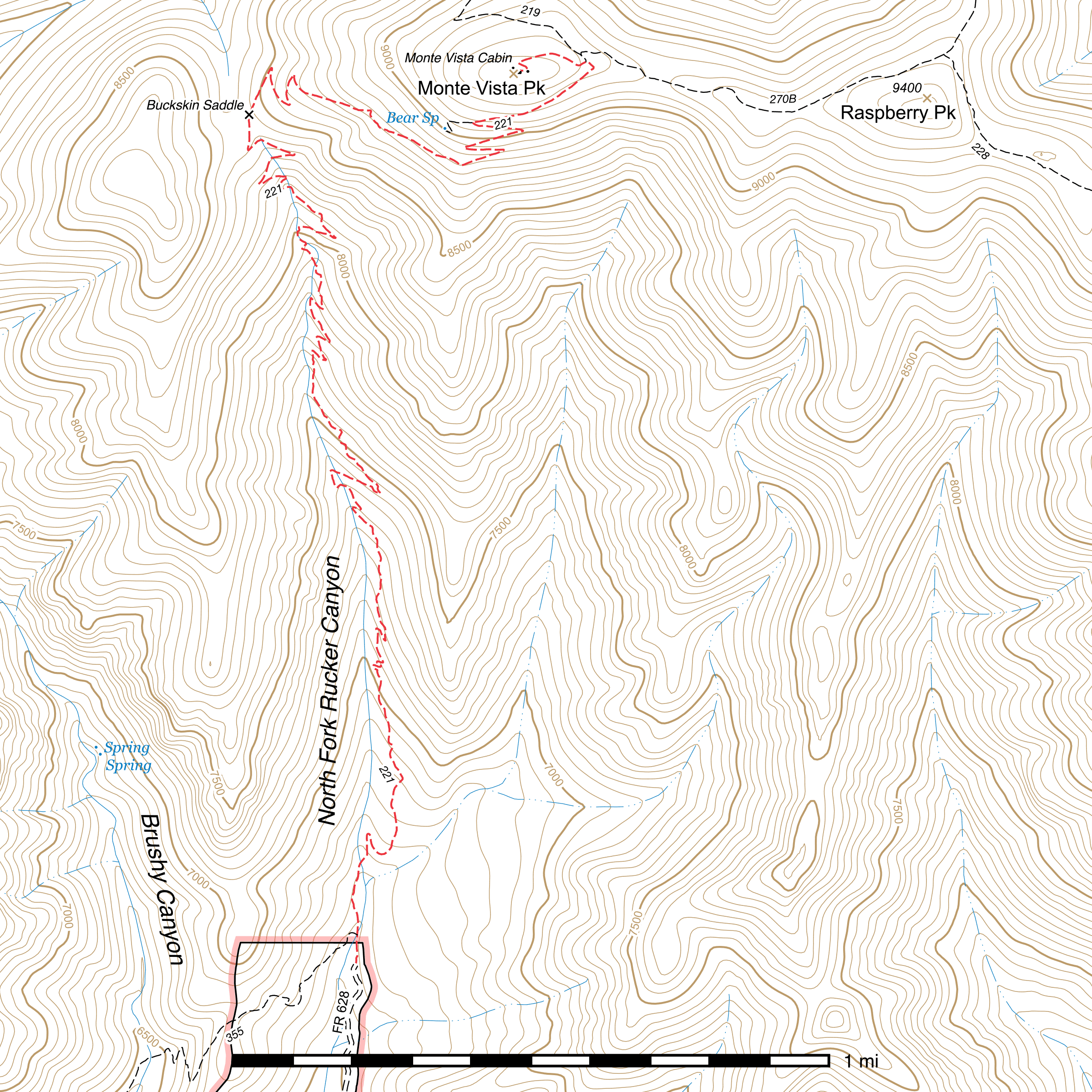
Monte Vista Trail #221
Important Note
Because the road is mostly undriveable, consider taking the Brushy Canyon Trail to connect to the Monte Vista Trail just past its own trailhead.
This trail is also sometimes referred to as the "North Fork Trail".
Current Conditions
This trail received major maintenance in 2019, 2021 and 2022, and has had some deadfall removed since then, but has multiple washouts in various points.
Length: 4.09 mi
Difficulty: moderate
Condition: moderate
Elevation range: 6620 ft – 9330 ft
Access
The Monte Vista Trail is accessible from three locations.
The lower elevation southern terminus is at the end of the rough, washed out North Fork Rucker Canyon Road (FR 628). High clearance vehicles are a must for this road and you will reach a point where you have to to park and walk the remaining distance. Drive up Rucker Canyon Road (FR 74E) 4.66 miles to just beyond Cypress Park Campground. After crossing Rucker Creek, you will very shortly make a left turn at a corral onto FR 628. (31.77677, -109.31245) The trailhead is 1.8 miles north. (31.79954, -109.31970)
The Brushy Canyon Trail connects in from the southwest only 300 feet north of the trailhead. (31.80040, -109.31965) This junction is not signed, but that trail heads west-northwest to cross the creek before swinging south on the opposite side and climbing southwest towards a saddle.
The Turtle Mountain Trail dead ends at the Monte Vista Trail 0.17 mile before reaching the top of Monte Vista Peak, (31.82530, -109.31313) and the Crest Trail does the same 80 feet northwest along the Turtle Mountain Trail. (31.82548, -109.31326)
Another popular approach to Monte Vista Peak is to take the Morse Canyon Trail out of West Turkey Creek to the Turtle Mountain Trail, only using the Monte Vista Trail for the final short climb.
Trail Description
Trailhead to Buckskin Saddle
- 2.71 mi
- 1850 ft ↑
- 12.9% slope
The Monte Vista Trail begins at the end of the North Fork Rucker Canyon Road (FR 628). (31.79954, -109.31970) Going straight north from here, the trail very quickly meets the eastern terminus of the Brushy Canyon Trail after 300 feet. (31.80040, -109.31965) There is no sign or visible trail here, but there may be rock cairns. Head west-northwest and cross the creek and you will shortly come to a more visible path on the opposite bank.
Back to the Monte Vista Trail, it continues basically north. The original route crossed the creek, paralleled a washout, and crossed back again. In 2021 and 2022, the trail was rerouted to climb north-northeast across a side drainage and reconnect with the trail for approximately 1,000 feet to just before a wide 180° turn. (31.80328, -109.31934) Recent visits to this trail suggest the reroute has not been getting used lately and is heavily overgrown. It is quite wide here and is likely on the remnants of an abandoned road. Over the next approximately 400 feet it gradually curves back to the north while climbing to a shelf above the bottom of the canyon.
After passing through a short layer of somewhat burned oak trees, the remnants of the old road end after a little over 0.1 mile (likely the original trailhead) and it's all single track trail from there on, (31.80454, -109.31860) with tall, largely unburned pines dominating the landscape for most of the rest of the hike.
From here on out, the trail is largely in excellent condition and very easy to follow. Frequent switchbacks and some steep climbing ensue. It crosses back and forth across the creek several times as it climbs farther up the canyon. After about 0.9 mile (31.82044, -109.32044) it passes through a patch of burned trees for 0.16 mile, and you may encounter blown over trees across the trail here. ⅓ mile later, the trail crosses Buckskin Saddle, (31.82379, -109.32273) which is marked by a sign. There is a lot of standing dead mixed in among live trees here, and it is unfortunately not a great place for camping at present.
Buckskin Saddle to Bear Spring Trail
- 0.95 mi
- 635 ft ↑
- 12.7% slope
Climbing out of the saddle to the north-northwest for 0.1 mile, the trail then switchbacks three times before entering a largely straight climb to the southeast for 0.36 mile. Another four switchbacks follow over 0.34 mile, passing almost entirely through a grassy, treeless zone that was burned in an earlier fire. These switchbacks have been very prone to erosion lately. At the last switchback in this segment, a sign marks the junction with the Bear Spring Trail, (31.82356, -109.31638) which heads west before rapidly losing elevation. This is a very short, very steep trail to the only natural source of water in the area.
Bear Spring Trail to Turtle Mountain Trail
- 0.26 mi
- 140 ft ↑
- 10.2% slope
The Monte Vista Trail heads east-northeast out of the switchback, slowly curving to the northeast over 0.24 mile before abruptly changing direction to the northwest (31.82515, -109.31291) for the remaining hundred feet to the signed junction with the Turtle Mountain Trail, (31.82530, -109.31313) which connects in from the north. The Crest Trail lies 80 feet north along that trail.
Turtle Mountain Trail to Monte Vista Fire Lookout
- 0.17 mi
- 125 ft ↑
- 13.9% slope
The remaining climb to the top of Monte Vista Peak is relatively short and steep. It starts climbing immediately out of the junction, initially heading southwest as it climbs the ridge, then swinging northwest and contouring around the north side of the peak. After a pair of switchbacks, it emerges just below a storage shed on the east side of the lookout complex. A cabin, the lookout tower itself, and an outhouse lie to the west. A spectacular view of the entire region can be had from the helispot (31.82493, -109.31559) and surrounding clearing west of the tower. During fire season, the tower may be staffed.
Map
Last updated July 14, 2025.