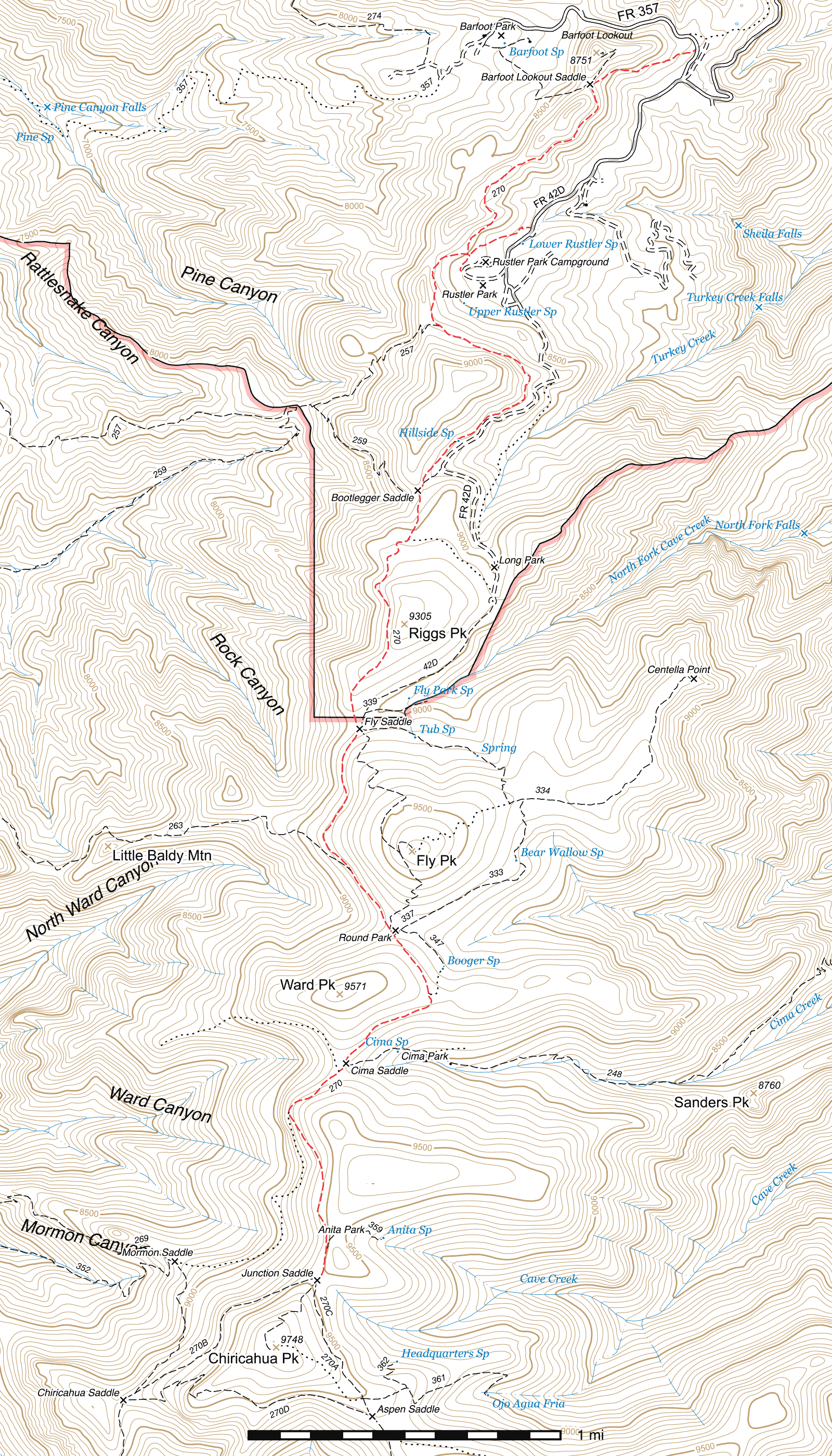
Crest Trail #270 (FR 357 to Junction Saddle)
Important Note
There is a day use fee to park at the Rustler Park trailhead just outside of the campground. Follow signage appropriately.
Current Conditions
As of July 2025, this section of the Crest Trail is clear of deadfall along its entire length and Wild Arizona's Youth Conservation Corps program has recently worked on improving tread conditions between Rustler Park and the Wilderness boundary north of Fly Saddle. Other tread conditions are generally good.
Length: 6.16 mi
Difficulty: easy
Condition: good
Elevation range: 8210 ft – 9500 ft
Access
The Crest Trail is accessible from many locations along the Chiricahua crest. Major access points for this leg of the Crest include:
The northern terminus (31.91693, -109.26827) is along the Barfoot Park Road (FR 357), 0.14 mile north of its junction with the Rustler Park Road (FR 42D). This trailhead is signed, but there is no parking immediately across from it, so it is better to park at the junction and walk there.
The Barfoot Park Trail climbs half a mile starting from the southwest corner of the meadow at Barfoot Park (31.91697, -109.27995) to meet the Crest at Barfoot Lookout Saddle. (31.91479, -109.27410)
The primary trailhead exists just outside the Rustler Park gate. (31.90686, -109.27724) There is a large parking lot across the road from the trailhead with dual vault toilets. A 0.26 mile spur trail climbs to the southwest and connects into the Crest at the Rustler Park Junction. (31.90552, -109.28077) As of April 2017, there is a $5 day use fee to park here.
The Bootlegger Trail climbs steeply to the Crest at a signed junction above Rustler Park. (31.90162, -109.28226)
A 450 foot spur trail meets the Crest at the north edge of Bootlegger Saddle (31.89305, -109.28318) from a bend in the Long Park Road (FR 42D). (31.89389, -109.28211) The Rock Creek Trail connects in at the south edge of the saddle, and as of early May 2016, it has a new trail sign visible from the Crest. (31.89246, -109.28368)
The 0.68 mile long Long Park Trail connects to the Crest at Fly Saddle (31.87965, -109.28665) from the end of the Long Park Road (FR 42). (31.88653, -109.27931)
The Saulsbury Trail climbs steeply from its trailhead in West Turkey Creek to meet the Crest a little over a quarter mile northwest of Round Park. (31.87195, -109.28715)
The Greenhouse Trail connects in from the east at Cima Park. (31.86141, -109.28739)
The southern terminus is at Junction Saddle, (31.84959, -109.28897) which can be reached via the other two legs of the Crest Trail or the Chiricahua Peak Trail. This junction is marked with multiple signs, though some are currently incorrectly numbered.
Trail Description
Barfoot Park Road (FR 357) to Barfoot Lookout Saddle
- 0.4 mi
- 280 ft ↑
- 13.3% slope
The Crest Trail climbs immediately away from the Barfoot Park Road (FR 357), cutting up the south slope of Buena Vista Peak heading west-southwest. This area, once heavily forested, was badly burned by the 2011 Horseshoe 2 fire and while some trees remain standing, nearly all are dead. At the end of this segment, the trail reaches Barfoot Lookout Saddle directly south of Buena Vista Peak, a signed junction with the Barfoot Lookout Trail (31.91479, -109.27410) which connects Barfoot Park to the top of Buena Vista Peak. The Crest Trail continues south via the leftmost fork in the junction.
Barfoot Lookout Saddle to Rustler Park Junction
- 0.9 mi
- 85 ft ↑ 205 ft ↓
- 2.5% slope
Largely remaining at a level elevation, this segment of the Crest heads southwest and stays on the southeastern side of the crest itself and dropping slightly in elevation as it approaches Rustler Park.
Rustler Park Junction to Bootlegger Trail
- 0.37 mi
- 195 ft ↑
- 10% slope
Two spur trails connect in at this signed junction, (31.90551, -109.28077) one from the upper loop of the Rustler Park Campground and the other from the parking lot outside Rustler Park, just in front of the gate along the Rustler Park Road (FR 42D). Those two trails have their own junction a short distance to the southeast and combine into a single trail which continues to this junction.
The Crest Trail heads west from here and curves around to the south as it ascends the slope of the actual crest of the Chiricahuas, at times only a short distance from the top. A little over two tenths of a mile after beginning to head south, and a very short distance after curving again towards the southwest, the Bootlegger Trail climbs away to the ridgetop off the right side of the trail. (31.90162, -109.28226).
Bootlegger Trail to Bootlegger Saddle
- 0.93 mi
- 200 ft ↑ 45 ft ↓
- 3.2% slope
The trail heads along the northwest face of the hill south of Rustler Park, visible along the Rustler Park Road in places. After two tenths of a mile, with a short but steep stretch or two along the way, there is a point directly beneath the prominent rock cliffs on the hill's face which frequently washes out or has debris from above drop onto the trail for a short stretch. Crossing this is usually not especially difficult, but care should be taken especially after winter, as there is a significant drop to one side of the trail. Frequent work has to be done here to keep this area in passable condition.
From here, the trail continues southeast a short distance before swinging south. Within a tenth of a mile you should be able to see the Long Park Road (FR 42D) not far below the trail, following the same basic route for a while. Three tenths of a mile further and the trail passes through a gate of sorts and 200 feet after that, a 60 foot spur trail leaves to the east and drops to Hillside Spring. (31.89531, -109.28149) Note that the sign at the spring lists this segment of the Crest Trail as being the Bootlegger Trail, which is no longer the case.
It's nearly two tenths of a mile further to the north edge of the meadow at Bootlegger Saddle, where two junctions occur. The first is a 450 foot spur trail which drops away northeast to the Long Park Road (31.89305, -109.28318) and the second, the southern terminus of the Rock Creek Trail, lies 200 feet beyond along the Crest Trail at the southern edge of Bootlegger Saddle. (31.89255, -109.28339) There is not a visible trail junction here, but head west approximately 80 feet through the meadow and a trail sign should be found. (31.89256, -109.28367) The Rock Creek Trail drops away to the south and begins a steep, switchbacking descent from here towards Rock Saddle.
Bootlegger Saddle to Fly Saddle
- 1.07 mi
- 270 ft ↑ 105 ft ↓
- 2.9% slope
The Crest Trail leaves Bootlegger Saddle heading south, and widens for a stretch, climbing along the way. The first portion of this section along with the earlier spur trail down to the Long Park Road remains wider than the normal Crest Trail width due to its use as a dozer line during the 1994 Rattlesnake fire. 0.18 miles south of Bootlegger Saddle, the Long Park Connector Trail, an unmaintained old roadbed (likely part of that same dozer line), forks off to the east, (31.88910, -109.28394) bending to the southeast along the way and ending up at Long Park. The Crest Trail narrows to a standard tread width again here and curves to the west for a short stretch, leveling out somewhat for a time. A bit of an S-curve follows over the next tenth of a mile before the trail emerges from under pine canopy to cross a barren stretch. The lack of trees here at least provides an excellent view out over the west side of the Chiricahuas.
0.15 miles beyond, the trail re-enters forested terrain, though this does not last and another barren slope must be crossed shortly after, this one extending the remaining distance to Fly Saddle with only a few patches of living trees between aside from young aspen. This area can provide a fantastic view of Fly Peak in the fall with its aspen turning color.
250 feet before Fly Saddle, the Wilderness boundary is crossed. (31.88030, -109.28692) The saddle itself is a five-way signed junction on the boundary between an aspen and a raspberry patch. (31.87965, -109.28665) The Crest Trail comes in from the northwest and departs to the southwest, the Long Park Trail heads northeast to the end of the Long Park Road, the Centella Trail east out to Centella Point and the Fly Peak Trail southeast to climb up and back down the other side of that peak to Round Park.
Fly Saddle to Saulsbury Junction
- 0.6 mi
- 105 ft ↑ 5 ft ↓
- 3.2% slope
Patchy burns remain the norm through here as the Crest Trail passes to the west of Fly Peak. After a quarter mile, the trail turns southwest and shortly after enters a thicker stretch of conifers before swinging around to the southeast, exiting onto another barren and very steep slope and coming to Saulsbury Junction, where the Saulsbury Trail leaves on the right side of the trail, heading northwest, almost paralleling the Crest Trail for a short while as it drops away steeply. (31.87195, -109.28714) This junction is marked with a sign, but depending on the season the Saulsbury Trail may be somewhat overgrown with ferns.
Saulsbury Junction to Round Park
- 0.25 mi
- 95 ft ↑ 10 ft ↓
- 6.4% slope
Continuing along the barren slope with a very steep drop off the right side, the trail maintains its southeasterly course the remaining short distance to Round Park, which is nestled in a saddle on the south side of Fly Peak. This area has been hit badly by fire and while there are still living trees in the area immediately around the Park's meadow, they are fairly limited in number. The trail cuts diagonally across the meadow and after approximately 60 feet, the Fly Peak Trail connects in. (31.86884, -109.28508) While the sign for that trail is about 35 feet to the northwest (31.86892, -109.28506), the tread should be visible where it leaves the Crest Trail near the Round Park sign.
Nearly 200 feet beyond, at the southeastern edge of Round Park, (31.86842, -109.28480) the Bear Wallow Trail connects in, heading northeast to pass along the east side of Fly Peak and connect midway along the Centella Trail. The Booger Spring Trail forks off the Bear Wallow Trail a short distance to the north.
Round Park to Cima Saddle
- 0.7 mi
- 70 ft ↑ 115 ft ↓
- 1.2% slope
Continuing its southeasterly heading, the trail exits Round Park almost immediately after the last junction and begins climbing to a saddle between Ward Peak and Wattmid Ridge. This stretch has a large number of young aspen trees mixed in among the more sparse pines, firs and spruce. Shortly before the saddle, the conifers become thicker, and approximately a quarter mile beyond Round Park a faint trail junction may be seen on the left. (31.86524, -109.28290) This is the abandoned southern half of the Booger Spring Trail.
150 feet beyond, you will exit the trees onto the saddle. The patch of fire damage here makes it possible to look down into Greenhouse Canyon to the south. The trail swings to the southwest and begins its 0.4 mile descent to Cima Saddle, which was hit by the fire but still has many standing trees—but almost as many fallen ones. The Greenhouse Trail descends to the east from here. (31.86141, -109.28739) The Ward Canyon Trail once dropped down the ridge to the northwest to Helispot 31, but this trail has been abandoned and due to the extensive fire damage and erosion along the slope it once passed across, there is virtually no trace of it remaining. The Crest Trail continues to the southwest.
Cima Saddle to Anita Park Junction
- 0.82 mi
- 230 ft ↑
- 5.3% slope
Exiting the southern edge of Cima Saddle, the trail heads southwest and passes through a grove of young aspen trees. There are almost no large standing trees along the trail through this entire segment, largely as a result of the 1994 Rattlesnake Fire and the subsequent 2011 Horseshoe II fire. After a quarter mile, you will swing around to the southeast, and 0.16 miles beyond that bend you pass the point the Upper Mormon Ridge Trail once descended to the south and connected with the Mormon Ridge Trail. (31.85704, -109.28947) Unless you are up for a route-finding adventure, to reach the Mormon Ridge Trail now you will need to continue on the Crest Trail beyond Junction Saddle to Chiricahua Saddle and then descend from there to Mormon Saddle.
Back to the Crest—you will gradually swing around to the south and after nearly three tenths of a mile the trail enters a more recent burn, where the Horseshoe 2 fire took out what was untouched by the Rattlesnake. A few trees do remain, but the majority here were obliterated, only their blackened stumps remaining. After passing under a rock ledge after about a tenth of a mile, the Anita Park Trail climbs away to the northwest on the left side of the trail. (31.85127, -109.28848)
Anita Park Junction to Junction Saddle
- 0.12 mi
- 5 ft ↑ 10 ft ↓
- 0.8% slope
This extremely short segment continues south from Anita Park and swings around gently to the right until it reaches Junction Saddle (31.8496, -109.28898), a four-way junction with the Chiricahua Peak Trail to the southwest, the western leg of the Crest Trail #270B heading west (before swinging southwest towards to its terminus at Monte Vista Peak), and the eastern leg of the Crest Trail #270C to the south (before swinging southeast to its terminus at Sentinel Peak).
Map
Last updated July 14, 2025.